IMAGES TAKEN NEAR TO
Coombe Road, BRIGHTON, BN2 4FL
Introduction
This page details the photographs taken nearby to Coombe Road, BN2 4FL by members of the Geograph project.
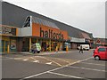
The Geograph project started in 2005 with the aim of publishing, organising and preserving representative images for every square kilometre of Great Britain, Ireland and the Isle of Man.

There are currently over 7.5m images from over14,400 individuals and you can help contribute to the project by visiting https://www.geograph.org.uk
Image Map
Images are licensed for reuse under creativecommons.org/licenses/by-sa/2.0
Notes
- Clicking on the map will re-center to the selected point.
- The higher the marker number, the further away the image location is from the centre of the postcode.
Image Listing (94 Images Found)
Images are licensed for reuse under creativecommons.org/licenses/by-sa/2.0
Image
Details
Distance
1
Carpetright, Lewes Road
Located opposite Lewes Road retail park at the junction with Coombe Road
Image: © Paul Gillett
Taken: 15 Apr 2012
0.00 miles
2
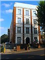
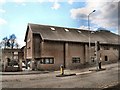
The Deco Building, Coombe Road, Brighton
A former factory building that has now been converted into flats. It was built at the end of the First World War specifically to employ disabled war veterans and initially occupied by Oppenheimer's National Diamond Works. Opened in 1918 the venture lasted only a few years being hit by the post war depression and the death of Bernard Oppenheimer and was wound up around 1924. It later became the home of Dentsply, who manufactured false teeth, until 1991 when they too closed. After a few years standing empty the building was totally refurbished and converted to residential use around 2000. There is another on the southern side of Coombe Road of which this is an extension that is also standing but is current used as a storage facility.
Image: © Simon Carey
Taken: 11 Oct 2015
0.01 miles
3
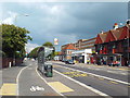
Cycle lane and bus stop, Lewes Road, Brighton
This cycle lane in Brighton passes behind the bus stop, enabling cyclists to pass stationary buses more safely.
Image: © Malc McDonald
Taken: 14 Sep 2014
0.03 miles
4
Lewes Road Retail Park
Showing Halfords and Comet
Image: © Paul Gillett
Taken: 20 Jul 2010
0.04 miles
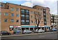
5
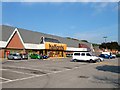
Pavilion Retail Park, Lewes Road, Brighton
Built in the late 1980s on the southern part of the old Preston Barracks demolishing virtually all the original surviving buildings from the late 18th century in the process. There are three retail units though only two were occupied at this time, Halfords in view and B & Q through the trees to the right, both have been here since the park opened. The empty unit was occupied by Comet from 1990 until the end of 2012 when they went bust. The park is looking very shabby at the moment.
Image: © Simon Carey
Taken: 11 Oct 2015
0.06 miles
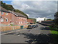
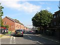
6
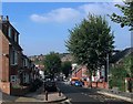
Coombe Road, Brighton
A residential road that links Lewes Road to Bevendean Road and as such is a bit of a rat run as those using this route avoid the Vogue Gyratory. The road was developed in stages with the western end in view completed during the 1900s and the eastern end further up the hill not finished until the early 1920s.
Image: © Simon Carey
Taken: 11 Oct 2015
0.08 miles
7
URC Christian Centre, Lewes Road
The church moved to this location from Image]
Image: © Paul Gillett
Taken: 15 Apr 2012
0.09 miles
8

Milner Road, Brighton
A residential road that runs between Baden Road and Dewe Road with this section to the west built in the 1900s and the eastern section not completed until the early 1920s. Like many roads on the estate named after those with connections to the Boer War, in this instance Sir Alfred Milner, British Commissioner in South Africa.
Image: © Simon Carey
Taken: 11 Oct 2015
0.09 miles
9
Saunders Park View, Brighton
A small estate of Lewes Road which consists of two branches, a southern and northern one. This is the northern part which was built in the late 1980s by the council on land obtained from neighbouring Preston Barracks. The building visible in the distance is the Watts Building part of the University of Brighton.
Image: © Simon Carey
Taken: 11 Oct 2015
0.09 miles