IMAGES TAKEN NEAR TO
Heath Hill Avenue, BRIGHTON, BN2 4FH
Introduction
This page details the photographs taken nearby to Heath Hill Avenue, BN2 4FH by members of the Geograph project.
The Geograph project started in 2005 with the aim of publishing, organising and preserving representative images for every square kilometre of Great Britain, Ireland and the Isle of Man.

There are currently over 7.5m images from over14,400 individuals and you can help contribute to the project by visiting https://www.geograph.org.uk
Image Map
Images are licensed for reuse under creativecommons.org/licenses/by-sa/2.0
Notes
- Clicking on the map will re-center to the selected point.
- The higher the marker number, the further away the image location is from the centre of the postcode.
Image Listing (11 Images Found)
Images are licensed for reuse under creativecommons.org/licenses/by-sa/2.0
Image
Details
Distance
1
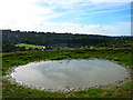
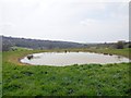
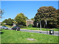
Dewpond, Bevendean
The dewpond is situated in the V of where the bridleway meets the footpath above Bevendean. Bevendean is another suburb built in a dip within the downs surrounded by steep hills. The green space to the left is Plymouth Avenue whilst the only exit is to the right between the spurs of the hill. This view looks south
Image: © Simon Carey
Taken: 9 Oct 2005
0.08 miles
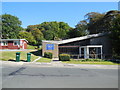
4
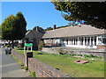
Hazelgrove nursing home, Bevendean
In Upper Bevendean Avenue
Image: © Paul Gillett
Taken: 30 Sep 2015
0.13 miles
5
Holy Nativity church, Bevendean
Anglican church built in 1963 as a Modern-style building in brick by architect Reginald Melhuish https://en.wikipedia.org/wiki/Bevendean
Image: © Paul Gillett
Taken: 30 Sep 2015
0.14 miles
6
Holy Nativity church hall, Bevendean
Anglican church built in 1963 as a Modern-style building in brick by architect Reginald Melhuish https://en.wikipedia.org/wiki/Bevendean
Image: © Paul Gillett
Taken: 30 Sep 2015
0.14 miles
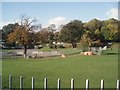
7
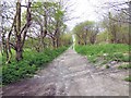
Lower Bevendean
Looking south across a school field towards Taunton Road. This is the farthest end of the estate.
Image: © Simon Carey
Taken: 9 Oct 2005
0.19 miles
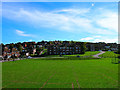
9
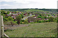
View over Bevendean
The near grassland is CRoW access downland on the slopes of Hogtrough Bottom, with housing at the bottom.
Image: © Robin Webster
Taken: 17 May 2010
0.21 miles
10
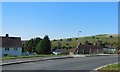
Norwich Drive, Bevendean
With Bevendean Down in the background
Image: © Paul Gillett
Taken: 30 Sep 2015
0.21 miles