IMAGES TAKEN NEAR TO
Eastbourne Road, BRIGHTON, BN2 4DL
Introduction
This page details the photographs taken nearby to Eastbourne Road, BN2 4DL by members of the Geograph project.
The Geograph project started in 2005 with the aim of publishing, organising and preserving representative images for every square kilometre of Great Britain, Ireland and the Isle of Man.

There are currently over 7.5m images from over14,400 individuals and you can help contribute to the project by visiting https://www.geograph.org.uk
Image Map
Images are licensed for reuse under creativecommons.org/licenses/by-sa/2.0
Notes
- Clicking on the map will re-center to the selected point.
- The higher the marker number, the further away the image location is from the centre of the postcode.
Image Listing (26 Images Found)
Images are licensed for reuse under creativecommons.org/licenses/by-sa/2.0
Image
Details
Distance
1
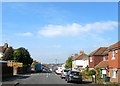
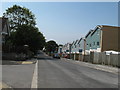
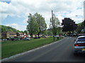
Eastbourne Road, Brighton
A residential road that links Bevendean Road to Canfield Road that was developed in the early 1920s.
Image: © Simon Carey
Taken: 11 Oct 2015
0.02 miles
2
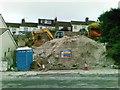
Development site, Carlyle Avenue, Brighton
Image: © Alex McGregor
Taken: 21 Jun 2011
0.09 miles
4
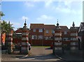
Former Bevendean Hospital Gates, Bevendean Road, Brighton
The gates date from around 1900 and along with the two lodges that flank them are the only surviving parts of Bevendean Hospital. Built as an isolation hospital in 1881 during the outbreak of a smallpox epidemic the original buildings were wooden and thrown up quickly. By the 1890s they had come to the end of their working life and were subsequently replaced in 1898 by new stone buildings which included the gates. A further two wings were added between 1902-1905. It operated primarily as an isolation hospital until 1948 when it became part of the National Health Service though ironically it was isolated during part of 1951 following a local smallpox outbreak. The hospital's last years were spent mainly caring for psychiatric and geriatric patients and was closed to in-patients in April 1989 and for good in September 1990 after which the buildings were demolished.
See http://www.bygones.org.uk/images/uploaded/scaled/Bevendean_Hospital41.jpg for an aerial image of the hospital.
Image: © Simon Carey
Taken: 11 Oct 2015
0.14 miles
5

Gates of former Bevendean Hospital, Brighton
Built in the late 19th century, Bevendean Hospital was closed in 1990 and then replaced by housing. These gates and gate piers on the south east side of Bevendean Road were retained and are Grade II Listed Buildings
Image: © Patrick Roper
Taken: 25 Aug 2010
0.15 miles
6
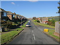
New housing on Bevendean Road
Looking at old Google images it appears that some of the houses in Baden Road, which back onto these new builds, have sold about half of their back gardens to accommodate.
Image: © Dave Spicer
Taken: 12 Aug 2012
0.15 miles
7
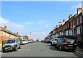
Nesbitt Road, Brighton
A residential road linking Milner Road to Natal Road that was developed in the 1900s. Named after Sir Randolph Cosby Nesbitt who was not involved in the Boer War but who won a VC during the Mashona Rebellion in Rhodesia in the 1890s.
Image: © Simon Carey
Taken: 11 Oct 2015
0.16 miles
8
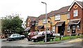
Borrow King Close, Brighton
Built around 2005, this short cul-de-sac is named after Arthur Borrow King (1924-1992), a Brighton councillor.
Image: © Patrick Roper
Taken: 25 Aug 2010
0.17 miles
9
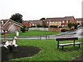
Playpark by Fitzherbert Drive
A children's play area in the Meadowview part of Brighton. Fitzherbert Drive is named after Mrs Fitzherbert who secretly married George IV when he was still Prince of Wales. She lived in Brighton for much of her life and is buried in Kemp Town.
Image: © Patrick Roper
Taken: 25 Aug 2010
0.17 miles
10
Lower Bevendean
Viewed from The Avenue
Image: © Paul Gillett
Taken: 26 May 2009
0.17 miles