IMAGES TAKEN NEAR TO
Birling Close, BRIGHTON, BN2 4DH
Introduction
This page details the photographs taken nearby to Birling Close, BN2 4DH by members of the Geograph project.
The Geograph project started in 2005 with the aim of publishing, organising and preserving representative images for every square kilometre of Great Britain, Ireland and the Isle of Man.

There are currently over 7.5m images from over14,400 individuals and you can help contribute to the project by visiting https://www.geograph.org.uk
Image Map
Images are licensed for reuse under creativecommons.org/licenses/by-sa/2.0
Notes
- Clicking on the map will re-center to the selected point.
- The higher the marker number, the further away the image location is from the centre of the postcode.
Image Listing (23 Images Found)
Images are licensed for reuse under creativecommons.org/licenses/by-sa/2.0
Image
Details
Distance
1
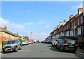
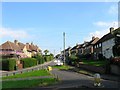
Nesbitt Road, Brighton
A residential road linking Milner Road to Natal Road that was developed in the 1900s. Named after Sir Randolph Cosby Nesbitt who was not involved in the Boer War but who won a VC during the Mashona Rebellion in Rhodesia in the 1890s.
Image: © Simon Carey
Taken: 11 Oct 2015
0.11 miles
2
Eastbourne Road, Brighton
A residential road that links Bevendean Road to Canfield Road that was developed in the early 1920s.
Image: © Simon Carey
Taken: 11 Oct 2015
0.12 miles
3
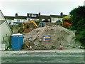
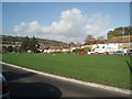
Development site, Carlyle Avenue, Brighton
Image: © Alex McGregor
Taken: 21 Jun 2011
0.13 miles
4
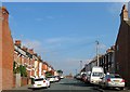
Buller Road, Brighton
A residential road that runs between Coombe road and Natal Road with this section north of Milner Road. Built in the 1900s and like many roads on the estate named after connections with the Boer War, in this instance Sir Redvers Buller who also had the street to the west named after him.
Image: © Simon Carey
Taken: 11 Oct 2015
0.15 miles
5
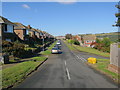
Southall Avenue, Moulescomb, Brighton
The southern tip of the estate that was built in the 1920s viewed from the junction with Natal Road. The road heads north to The Avenue.
Image: © Simon Carey
Taken: 11 Oct 2015
0.16 miles
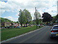
6
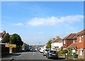
The Avenue - Bevendean
The Avenue is the main entry road into Bevendean.
Image: © Paul Gillett
Taken: 25 Oct 2009
0.16 miles
7

Redvers Road, Brighton
A residential road that runs between Milner Road and Natal Road. The estate was developed in the 1900s and the road names have many connections to the Boer War, in the instance General Sir Redvers Bullers who also had the neighbouring street named after him.
Image: © Simon Carey
Taken: 11 Oct 2015
0.17 miles
9
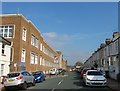
Dewe Road, Brighton
A residential road that runs between Coombe Road and Natal Road and was built sometime in the early 1900s. The building on the left is the rear of the University of Brighton's Mithras House built in 1966 as an administration block for Allen West Ltd, an engineering works, and sold to the then Polytechnic in 1977
Image: © Simon Carey
Taken: 11 Oct 2015
0.19 miles
10
Lower Bevendean
Viewed from The Avenue
Image: © Paul Gillett
Taken: 26 May 2009
0.19 miles