IMAGES TAKEN NEAR TO
Pebble Road, PEVENSEY, BN24 6NH
Introduction
This page details the photographs taken nearby to Pebble Road, BN24 6NH by members of the Geograph project.
The Geograph project started in 2005 with the aim of publishing, organising and preserving representative images for every square kilometre of Great Britain, Ireland and the Isle of Man.

There are currently over 7.5m images from over14,400 individuals and you can help contribute to the project by visiting https://www.geograph.org.uk
Image Map
Images are licensed for reuse under creativecommons.org/licenses/by-sa/2.0
Notes
- Clicking on the map will re-center to the selected point.
- The higher the marker number, the further away the image location is from the centre of the postcode.
Image Listing (58 Images Found)
Images are licensed for reuse under creativecommons.org/licenses/by-sa/2.0
Image
Details
Distance
1
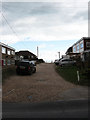
Pebble Road
Private road linking Coast Road to the beach. It was also the site of Martello Tower number 58 which was demolished sometime in the 1920s with the road still marked on a map of 1951 as Martello Road.
Image: © Simon Carey
Taken: 14 Mar 2010
0.01 miles
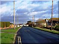
4
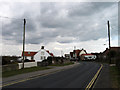
Coast Road
Minor road that runs parallel to the beach until it reaches the eastern edge of the parish of Pevensey and becomes a private road leading to Normans Bay. The bend in the road is to bridge Salt Haven.
Image: © Simon Carey
Taken: 14 Mar 2010
0.05 miles
5
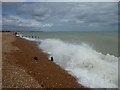
Waves at Pevensey Beach
This was an hour before high tide with August Storm Ellen still blowing. Fairlight Cliffs beyond Hastings can be seen in the far distance.
Image: © Marathon
Taken: 23 Aug 2020
0.06 miles
6

Groyne
The remains of a groyne on the beach at Pevensey Bay.
Image: © Ian Capper
Taken: 15 Feb 2019
0.06 miles
7

Low Tide, Pevensey Bay
More messages written in the sand though quite what 'puppy poo' is about I know not what. Beyond on the shingle bank that acts as a sea defence are the houses of Pevensey Bay.
Image: © Simon Carey
Taken: 14 Mar 2010
0.07 miles
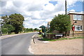
8

Ethel Wood Community Centre
Located on Coast Road next to the Beachlands estate.
Image: © Simon Carey
Taken: 14 Mar 2010
0.07 miles
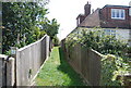
9

Cobald Road
Houses in Cobald Road overlooking the beach at Pevensey Bay.
Image: © Ian Capper
Taken: 15 Feb 2019
0.07 miles