IMAGES TAKEN NEAR TO
Coast Road, PEVENSEY, BN24 6LP
Introduction
This page details the photographs taken nearby to Coast Road, BN24 6LP by members of the Geograph project.
The Geograph project started in 2005 with the aim of publishing, organising and preserving representative images for every square kilometre of Great Britain, Ireland and the Isle of Man.

There are currently over 7.5m images from over14,400 individuals and you can help contribute to the project by visiting https://www.geograph.org.uk
Image Map
Images are licensed for reuse under creativecommons.org/licenses/by-sa/2.0
Notes
- Clicking on the map will re-center to the selected point.
- The higher the marker number, the further away the image location is from the centre of the postcode.
Image Listing (137 Images Found)
Images are licensed for reuse under creativecommons.org/licenses/by-sa/2.0
Image
Details
Distance
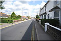
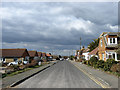
3
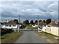
Eastbourne Avenue
Looking down at the junction with Coast Road whilst beyond is a small recreation ground.
Image: © Simon Carey
Taken: 14 Mar 2010
0.04 miles
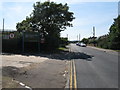
4
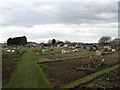
Footpath Through the Allotments
The footpath is an old right of way which once crossed a field called Great Bill Streaks according to the 1839 tithe map. Both allotments and the small estate built around Waverley Gardens were added during the 1960s.
Image: © Simon Carey
Taken: 14 Mar 2010
0.06 miles
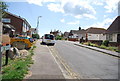
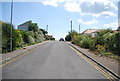
7
Channel View Road
It would be if I turned 180 degrees. This looks northwards towards the junction with Coast Road. The road was laid out in the first decade of the twentieth century and gradually developed from that point onwards.
Image: © Simon Carey
Taken: 14 Mar 2010
0.08 miles
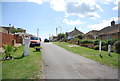
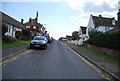
8
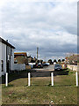
Eastbourne Avenue
The beach end of this private road that was laid out in the first decade of the 20th century then gradually built up over time. This is also roughly the site of Martello Tower number 95 which was demolished in 1903 specifically to build this road.
Image: © Simon Carey
Taken: 14 Mar 2010
0.09 miles