IMAGES TAKEN NEAR TO
Norman Road, PEVENSEY, BN24 6HX
Introduction
This page details the photographs taken nearby to Norman Road, BN24 6HX by members of the Geograph project.
The Geograph project started in 2005 with the aim of publishing, organising and preserving representative images for every square kilometre of Great Britain, Ireland and the Isle of Man.

There are currently over 7.5m images from over14,400 individuals and you can help contribute to the project by visiting https://www.geograph.org.uk
Image Map
Images are licensed for reuse under creativecommons.org/licenses/by-sa/2.0
Notes
- Clicking on the map will re-center to the selected point.
- The higher the marker number, the further away the image location is from the centre of the postcode.
Image Listing (136 Images Found)
Images are licensed for reuse under creativecommons.org/licenses/by-sa/2.0
Image
Details
Distance
1
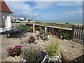
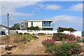
Stony garden at Pevensey Bay
This house at Pevensey Bay on the corner of Rosetti Road and Norman Road has made the most of the stony substrate to create its garden. See also https://www.geograph.org.uk/photo/6581538 Fairlight Cliffs, beyond Hastings, can be seen in the far distance.
Image: © Marathon
Taken: 23 Aug 2020
0.02 miles
3
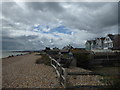
Gardens on the beach at Pevensey Bay
It is somewhat surprising how much of the shingle beach at Pevensey Bay has been taken up by people's private gardens. This is between Western Road and Leyland Road.
Image: © Marathon
Taken: 23 Aug 2020
0.03 miles
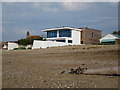
4
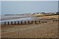
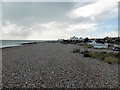
Beach at Pevensey Bay
Looking towards Sovereign Harbour.
Image: © Oast House Archive
Taken: 5 Jun 2015
0.04 miles
6
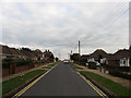
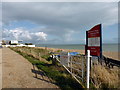
Rosetti Road
A residential road that runs south from the A259 to the beach.
Image: © Simon Carey
Taken: 24 Jan 2010
0.04 miles
8
Martello Tower number 60, Pevensey Bay, East Sussex
Converted to a home.
Image: © Oast House Archive
Taken: 7 Sep 2008
0.05 miles
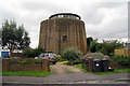
10
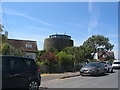
Martello tower, Leyland Road
Constructed in 1806 as one of a series of towers lining the south coast to defend against invasion by Napoleonic forces, it was converted to residential use c. 1985 and stands out among the surrounding dwellings.
Image: © E Gammie
Taken: 16 Jul 2018
0.06 miles