IMAGES TAKEN NEAR TO
Grenville Road, PEVENSEY, BN24 6BP
Introduction
This page details the photographs taken nearby to Grenville Road, BN24 6BP by members of the Geograph project.
The Geograph project started in 2005 with the aim of publishing, organising and preserving representative images for every square kilometre of Great Britain, Ireland and the Isle of Man.

There are currently over 7.5m images from over14,400 individuals and you can help contribute to the project by visiting https://www.geograph.org.uk
Image Map
Images are licensed for reuse under creativecommons.org/licenses/by-sa/2.0
Notes
- Clicking on the map will re-center to the selected point.
- The higher the marker number, the further away the image location is from the centre of the postcode.
Image Listing (84 Images Found)
Images are licensed for reuse under creativecommons.org/licenses/by-sa/2.0
Image
Details
Distance
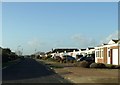
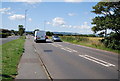
1
Innings Drive
Small residential area located between the A259 and the beach and entirely consisting of bungalows.
Image: © Simon Carey
Taken: 24 Jan 2010
0.02 miles
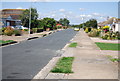

6
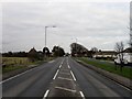
Eastbourne Road
Main A259 road linking Eastnbourne to Pevensey via Pevensey Bay. This part is on the western outskirts of the latter with the Holy Rood Catholic church to the left.
Image: © Simon Carey
Taken: 24 Jan 2010
0.07 miles
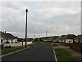
8
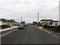
Grenville Road
Residential road linking Eastbourne Road, the A259, with the beach.
Image: © Simon Carey
Taken: 24 Jan 2010
0.07 miles

