IMAGES TAKEN NEAR TO
Coast Road, PEVENSEY, BN24 6AH
Introduction
This page details the photographs taken nearby to Coast Road, BN24 6AH by members of the Geograph project.
The Geograph project started in 2005 with the aim of publishing, organising and preserving representative images for every square kilometre of Great Britain, Ireland and the Isle of Man.

There are currently over 7.5m images from over14,400 individuals and you can help contribute to the project by visiting https://www.geograph.org.uk
Image Map
Images are licensed for reuse under creativecommons.org/licenses/by-sa/2.0
Notes
- Clicking on the map will re-center to the selected point.
- The higher the marker number, the further away the image location is from the centre of the postcode.
Image Listing (149 Images Found)
Images are licensed for reuse under creativecommons.org/licenses/by-sa/2.0
Image
Details
Distance
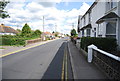
4
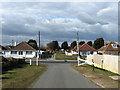
Waverley Gardens
Small estate squeezed between Coast Road and Salt Haven.
Image: © Simon Carey
Taken: 24 Jan 2010
0.05 miles
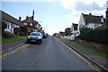
6
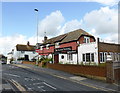
Eastbourne Avenue
Looking down at the junction with Coast Road whilst beyond is a small recreation ground.
Image: © Simon Carey
Taken: 14 Mar 2010
0.06 miles
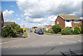
9
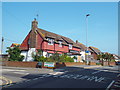
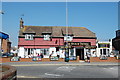
Beach Tavern, Pevensey Bay
The Beach Tavern was closed and its entrance door was boarded up when this image was taken in May 2018.
Image: © Malc McDonald
Taken: 26 May 2018
0.06 miles
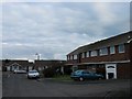
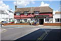
10
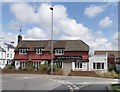
The Beach Tavern, Pevensey Bay
The pub has been closed for several years
Image: © PAUL FARMER
Taken: 6 Aug 2019
0.06 miles