IMAGES TAKEN NEAR TO
Darent Close, PEVENSEY, BN24 5PW
Introduction
This page details the photographs taken nearby to Darent Close, BN24 5PW by members of the Geograph project.
The Geograph project started in 2005 with the aim of publishing, organising and preserving representative images for every square kilometre of Great Britain, Ireland and the Isle of Man.

There are currently over 7.5m images from over14,400 individuals and you can help contribute to the project by visiting https://www.geograph.org.uk
Image Map
Images are licensed for reuse under creativecommons.org/licenses/by-sa/2.0
Notes
- Clicking on the map will re-center to the selected point.
- The higher the marker number, the further away the image location is from the centre of the postcode.
Image Listing (8 Images Found)
Images are licensed for reuse under creativecommons.org/licenses/by-sa/2.0
Image
Details
Distance
1
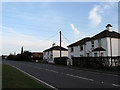
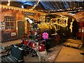
Red Dyke Cottages
Located on Ditton's Road, the B2247, and built in 1887.
Image: © Simon Carey
Taken: 21 Mar 2010
0.12 miles
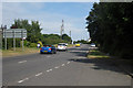
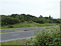
2
Access road for Stone Cross Garden Centre
Image: © nick macneill
Taken: 26 Feb 2010
0.19 miles
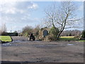
3
Walter House Wood
The name of the field according to the 1838 tithe map which was marked as arable back then the name a reminder of the woodland that once stood on this spot.
Image: © Simon Carey
Taken: 21 Mar 2010
0.19 miles
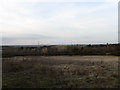
5
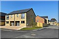
New housing development by Stone Cross Nursery
Image: © Oast House Archive
Taken: 19 Apr 2021
0.22 miles
7
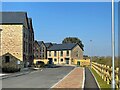
New housing development by Stone Cross Nursery
Image: © Oast House Archive
Taken: 19 Apr 2021
0.24 miles