IMAGES TAKEN NEAR TO
Church Bailey, PEVENSEY, BN24 5NQ
Introduction
This page details the photographs taken nearby to Church Bailey, BN24 5NQ by members of the Geograph project.
The Geograph project started in 2005 with the aim of publishing, organising and preserving representative images for every square kilometre of Great Britain, Ireland and the Isle of Man.

There are currently over 7.5m images from over14,400 individuals and you can help contribute to the project by visiting https://www.geograph.org.uk
Image Map
Images are licensed for reuse under creativecommons.org/licenses/by-sa/2.0
Notes
- Clicking on the map will re-center to the selected point.
- The higher the marker number, the further away the image location is from the centre of the postcode.
Image Listing (206 Images Found)
Images are licensed for reuse under creativecommons.org/licenses/by-sa/2.0
Image
Details
Distance
1
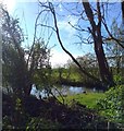
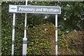
Pond behind Pevensey and Westham Station
Image: © PAUL FARMER
Taken: 1 May 2018
0.04 miles
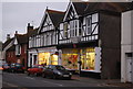
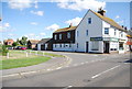
4
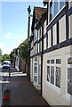
High Street
The main village street in Westham taken at dusk which is now the B2191 but was the A259 until the 1970s and the A27 to the early 1990s. The chemist on the right is now closed though the village still retains a post office, a hairdressers and a florist.
Image: © Simon Carey
Taken: 21 Mar 2010
0.06 miles
5
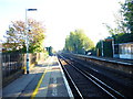
Pevensey & Westham station
The Brighton, Lewes & Hastings Railway existed from February 1844 but only operated trains for a few weeks during June and July 1846 before it was amalgamated with other companies to form the London Brighton & South Coast Railway on 27th July 1846. Pevensey & Westham station opened as Westham & Pevensey on the same day as the rest of the line (27th July 1846) between Lewes and St.Leonards (Bulverhythe). It was renamed Pevensey & Westham in January 1851 but in November 1851 was renamed Pevensey until January 1890 when it received its present name.
This view is from the Hastings-bound platform. The next station in this direction is Pevensey Bay - see https://www.geograph.org.uk/photo/4987412
Image: © Marathon
Taken: 21 Oct 2018
0.06 miles
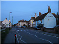
8
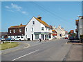
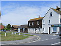
High Street, Westham
The high street in the village of Westham, near Eastbourne.
Image: © Malc McDonald
Taken: 26 May 2018
0.07 miles
10
Peelings Lane, Westham
At junction with the High Street
Image: © PAUL FARMER
Taken: 16 Jul 2009
0.07 miles