IMAGES TAKEN NEAR TO
High Street, PEVENSEY, BN24 5LX
Introduction
This page details the photographs taken nearby to High Street, BN24 5LX by members of the Geograph project.
The Geograph project started in 2005 with the aim of publishing, organising and preserving representative images for every square kilometre of Great Britain, Ireland and the Isle of Man.

There are currently over 7.5m images from over14,400 individuals and you can help contribute to the project by visiting https://www.geograph.org.uk
Image Map
Images are licensed for reuse under creativecommons.org/licenses/by-sa/2.0
Notes
- Clicking on the map will re-center to the selected point.
- The higher the marker number, the further away the image location is from the centre of the postcode.
Image Listing (201 Images Found)
Images are licensed for reuse under creativecommons.org/licenses/by-sa/2.0
Image
Details
Distance
4
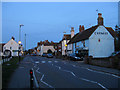
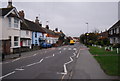
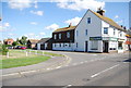
High Street
The main village street in Westham taken at dusk which is now the B2191 but was the A259 until the 1970s and the A27 to the early 1990s. The chemist on the right is now closed though the village still retains a post office, a hairdressers and a florist.
Image: © Simon Carey
Taken: 21 Mar 2010
0.05 miles
6
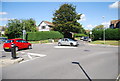
Mini-roundabout in Westham
A mini-roundabout in Westham, near Eastbourne.
Image: © Malc McDonald
Taken: 26 May 2018
0.06 miles
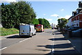
8
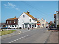
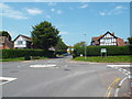
High Street, Westham
The high street in the village of Westham, near Eastbourne.
Image: © Malc McDonald
Taken: 26 May 2018
0.06 miles