IMAGES TAKEN NEAR TO
High Street, PEVENSEY, BN24 5LL
Introduction
This page details the photographs taken nearby to High Street, BN24 5LL by members of the Geograph project.
The Geograph project started in 2005 with the aim of publishing, organising and preserving representative images for every square kilometre of Great Britain, Ireland and the Isle of Man.

There are currently over 7.5m images from over14,400 individuals and you can help contribute to the project by visiting https://www.geograph.org.uk
Image Map
Images are licensed for reuse under creativecommons.org/licenses/by-sa/2.0
Notes
- Clicking on the map will re-center to the selected point.
- The higher the marker number, the further away the image location is from the centre of the postcode.
Image Listing (290 Images Found)
Images are licensed for reuse under creativecommons.org/licenses/by-sa/2.0
Image
Details
Distance
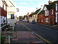
1
![Westham houses [6]](https://s3.geograph.org.uk/geophotos/07/21/63/7216319_761ba778_120x120.jpg)
Westham houses [6]
Tudor Court, High Street was built in the 17th century or, possibly, earlier. Timber framed, restored and refronted with stucco on ground floor and tile-hung above under a hipped tile roof. The extension on the right is 20th century. Listed, grade II, with details at: https://historicengland.org.uk/listing/the-list/list-entry/1028494
The village of Westham is adjacent to the village of Pevensey some five miles (8 km) northeast of Eastbourne. The village is located on a spur of land that was a peninsula that projected into a tidal lagoon, now reclaimed marshland. The village is part of the Greater Eastbourne conurbation, and much recent expansion has taken place. Today it is a commuter village.
Image: © Michael Dibb
Taken: 4 May 2022
0.00 miles
4
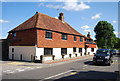
![Westham houses [7]](https://s1.geograph.org.uk/geophotos/07/21/63/7216337_0b0f885c_120x120.jpg)
Westham houses [7]
Old Oak House, number 84 High Street, was built in the 15th century. Timber framed, close-studded with plaster infill, jettied to the street, all under a hipped tile roof. Two first floor windows have original wooden mullions. The gable walls are tile-hung. Listed, grade II*, with details at: https://historicengland.org.uk/listing/the-list/list-entry/1184666
The village of Westham is adjacent to the village of Pevensey some five miles (8 km) northeast of Eastbourne. The village is located on a spur of land that was a peninsula that projected into a tidal lagoon, now reclaimed marshland. The village is part of the Greater Eastbourne conurbation, and much recent expansion has taken place. Today it is a commuter village.
Image: © Michael Dibb
Taken: 4 May 2022
0.02 miles
5
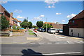
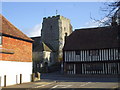
High Street, Westham
Westham is on the western side of Pevensey Castle and has an equally historical High Street. This view looks east just beyond the junction with Peelings Lane.
Image: © Simon Carey
Taken: 21 Jan 2006
0.02 miles
6
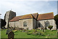
St Mary's church, Westham
One of the first churches built by the Normans in 1080
Image: © Julian P Guffogg
Taken: 2 Apr 2011
0.02 miles
8
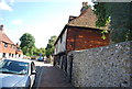
Court House
Grade II listed. http://www.britishlistedbuildings.co.uk/en-295520-the-court-house-and-wallby-pevensey-east
Image: © N Chadwick
Taken: 20 Aug 2014
0.02 miles