IMAGES TAKEN NEAR TO
Lilac Lane, PEVENSEY, BN24 5JN
Introduction
This page details the photographs taken nearby to Lilac Lane, BN24 5JN by members of the Geograph project.
The Geograph project started in 2005 with the aim of publishing, organising and preserving representative images for every square kilometre of Great Britain, Ireland and the Isle of Man.

There are currently over 7.5m images from over14,400 individuals and you can help contribute to the project by visiting https://www.geograph.org.uk
Image Map
Images are licensed for reuse under creativecommons.org/licenses/by-sa/2.0
Notes
- Clicking on the map will re-center to the selected point.
- The higher the marker number, the further away the image location is from the centre of the postcode.
Image Listing (37 Images Found)
Images are licensed for reuse under creativecommons.org/licenses/by-sa/2.0
Image
Details
Distance
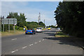
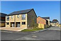
1
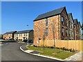
New housing development by Stone Cross Nursery
Image: © Oast House Archive
Taken: 19 Apr 2021
0.01 miles
2
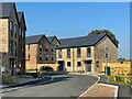
New housing development by Stone Cross Nursery
Image: © Oast House Archive
Taken: 19 Apr 2021
0.02 miles
3
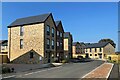
New housing development by Stone Cross Nursery
Image: © Oast House Archive
Taken: 19 Apr 2021
0.03 miles
4
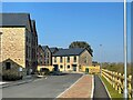
New housing development by Stone Cross Nursery
Image: © Oast House Archive
Taken: 19 Apr 2021
0.06 miles
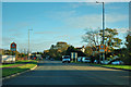
7
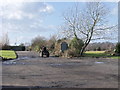
Access road for Stone Cross Garden Centre
Image: © nick macneill
Taken: 26 Feb 2010
0.07 miles
8
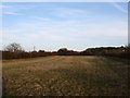
Great Field
The name of the field according to the 1838 tithe map which is the northern portion of a once much larger field that has been split in two by the construction of the Pevensey By-Pass. The rest of the field lies between that road and the B2247.
Image: © Simon Carey
Taken: 21 Mar 2010
0.08 miles
9
New housing development by Stone Cross Nursery
Image: © Oast House Archive
Taken: 19 Apr 2021
0.08 miles
10
Entering Stone Cross
A village beyond the Eastbourne borough boundary, but really part of the same conurbation.
Image: © Robin Webster
Taken: 17 Nov 2011
0.09 miles