IMAGES TAKEN NEAR TO
Forge Place, PEVENSEY, BN24 5GY
Introduction
This page details the photographs taken nearby to Forge Place, BN24 5GY by members of the Geograph project.
The Geograph project started in 2005 with the aim of publishing, organising and preserving representative images for every square kilometre of Great Britain, Ireland and the Isle of Man.

There are currently over 7.5m images from over14,400 individuals and you can help contribute to the project by visiting https://www.geograph.org.uk
Image Map
Images are licensed for reuse under creativecommons.org/licenses/by-sa/2.0
Notes
- Clicking on the map will re-center to the selected point.
- The higher the marker number, the further away the image location is from the centre of the postcode.
Image Listing (37 Images Found)
Images are licensed for reuse under creativecommons.org/licenses/by-sa/2.0
Image
Details
Distance
1
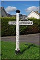
Old Direction Sign - Signpost by the B2014, Hailsham Road, Blackness
Black iron cap finial - 3 arms; East Sussex wood by the B2014, in parish of Westham (Wealden District), B2014 Hailsham Road, grass island at junction with Hankham Road.
Surveyed
Milestone Society National ID: SX_TQ6104.
Image: © Milestone Society
Taken: Unknown
0.06 miles
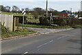
5
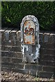
Old Milepost by the B2104, Hailsham Road, north west of Stone Cross
Metal plate attached to wooden post by the B2104, in parish of WESTHAM (WEALDEN District), North West of Stone Cross, opposite end of Milton Street, on garden wall of "Woodlands", on West side of road. Numbered iron plate, erected by the Horsebridge & Horeham turnpike trust in the 19th century.
Inscription reads:-
59
Milestone Society National ID: SX_LLE59.
Image: © JR Dowding
Taken: 11 Jul 2007
0.11 miles
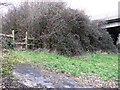
9
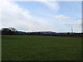
Peelings Field
The name of the field according to the 1838 tithe map. The South Downs provide the backdrop with Folkington and Wilmington Hills in the centre and Firle Beacon visible to the right.
Image: © Simon Carey
Taken: 20 Feb 2010
0.12 miles
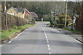
10
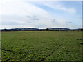
Bill Lands
The name of the field according to the 1838 tithe map which originally ran up the north side of Hankham Road to Hankham Cross but has since been obliterated and either built on or merged with other fields. The South Downs provides the backdrop.
Image: © Simon Carey
Taken: 20 Feb 2010
0.13 miles