IMAGES TAKEN NEAR TO
Lavant Road, PEVENSEY, BN24 5EZ
Introduction
This page details the photographs taken nearby to Lavant Road, BN24 5EZ by members of the Geograph project.
The Geograph project started in 2005 with the aim of publishing, organising and preserving representative images for every square kilometre of Great Britain, Ireland and the Isle of Man.

There are currently over 7.5m images from over14,400 individuals and you can help contribute to the project by visiting https://www.geograph.org.uk
Image Map
Images are licensed for reuse under creativecommons.org/licenses/by-sa/2.0
Notes
- Clicking on the map will re-center to the selected point.
- The higher the marker number, the further away the image location is from the centre of the postcode.
Image Listing (35 Images Found)
Images are licensed for reuse under creativecommons.org/licenses/by-sa/2.0
Image
Details
Distance

2

Telephone kiosk and pillarbox, Stone Cross
Image: © nick macneill
Taken: 16 Dec 2011
0.13 miles
3
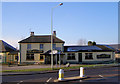
Red Lion, Stone Cross
At Stone Cross crossroads. The pub stands diagonally opposite St Luke's Church and is officially in Lion Hill.
Image: © Kevin Gordon
Taken: 4 Feb 2009
0.14 miles
5
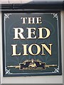
The Red Lion sign
Sign for Image, a Harveys of Lewes pub on Lion Hill.
Image: © Oast House Archive
Taken: 17 Apr 2012
0.15 miles
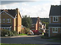
6
Rattle Road
Up until the early 1990s this was the A27 until the Pevensey By-Pass was built effectively relegating this road to a backwater used primarily for access to Stone Cross and Westham. The houses catching the late evening sun on the left are Woodville and Holly Cottage respectively. A local story explains that the name of the road was due to a nearby gallows in Westham where the unfortunate occupants' chains would rattle in the wind.
Image: © Simon Carey
Taken: 21 Mar 2010
0.15 miles
7

Statue of Jesus outside St Lukes Church
Image: © Julian P Guffogg
Taken: 3 Jun 2011
0.16 miles
8

St Lukes Church
Built in the 1920s to serve the newly expanding settlement of Stone Cross. The war memorial is also in view.
Image: © Simon Carey
Taken: 21 Mar 2010
0.16 miles
9

Stone Cross War Memorial
This is a granite celtic cross and shows the names of victims of the two world wars. The last two names are teenagers Myrtle Wilkinson and Peggy Harland. They were friends who went into Eastbourne to see a friend on 26th September 1940. They were caught in an air-raid and both were killed.
Image: © Kevin Gordon
Taken: 4 Feb 2009
0.16 miles
