IMAGES TAKEN NEAR TO
Mill Crest, PEVENSEY, BN24 5DU
Introduction
This page details the photographs taken nearby to Mill Crest, BN24 5DU by members of the Geograph project.
The Geograph project started in 2005 with the aim of publishing, organising and preserving representative images for every square kilometre of Great Britain, Ireland and the Isle of Man.

There are currently over 7.5m images from over14,400 individuals and you can help contribute to the project by visiting https://www.geograph.org.uk
Image Map
Images are licensed for reuse under creativecommons.org/licenses/by-sa/2.0
Notes
- Clicking on the map will re-center to the selected point.
- The higher the marker number, the further away the image location is from the centre of the postcode.
Image Listing (34 Images Found)
Images are licensed for reuse under creativecommons.org/licenses/by-sa/2.0
Image
Details
Distance

2
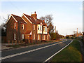
Rattle Road
Up until the early 1990s this was the A27 until the Pevensey By-Pass was built effectively relegating this road to a backwater used primarily for access to Stone Cross and Westham. The houses catching the late evening sun on the left are Woodville and Holly Cottage respectively. A local story explains that the name of the road was due to a nearby gallows in Westham where the unfortunate occupants' chains would rattle in the wind.
Image: © Simon Carey
Taken: 21 Mar 2010
0.08 miles
3

Peelings Lane
This, the western end, is now effectively a bridleway, with barriers and a ban on motorized vehicles. The tarmac surface remains under the leaves.
Image: © Robin Webster
Taken: 17 Nov 2011
0.10 miles
4

Telephone kiosk and pillarbox, Stone Cross
Image: © nick macneill
Taken: 16 Dec 2011
0.11 miles
5

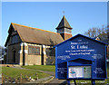
St Lukes Church
Built in the 1920s to serve the newly expanding settlement of Stone Cross. The war memorial is also in view.
Image: © Simon Carey
Taken: 21 Mar 2010
0.12 miles
6
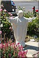
Statue of Jesus outside St Lukes Church
Image: © Julian P Guffogg
Taken: 3 Jun 2011
0.12 miles
7
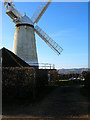
Stone Cross Windmill
Built in 1875, it was the last tower mill to be built in Sussex. The mill ceased working in 1937 and although it became a grade II* listed building in 1952 it was becoming increasingly dilapidated. However, the Sussex Mills Group and Wealden Council began restoration work in 1995 and the mill began grinding corn again in 2000. It is open to the public from 2-5pm every Sunday between April and September. This view looks west from behind the mill and takes in the Downs above Folkington in the distance.
Image: © Simon Carey
Taken: 21 Jan 2006
0.12 miles
8
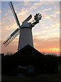
Stone Cross Windmill at Sunset
See Image for its history. Beyond the windmill the sun is beginning to dip behind Folkington Hill.
Image: © Simon Carey
Taken: 19 Feb 2008
0.12 miles
9
St Luke's Church, Stone Cross
This brick built church was completed in 1929. It fell into disrepair in the 1970s but was reopened in 1988.
Image: © Kevin Gordon
Taken: 4 Feb 2009
0.13 miles
