IMAGES TAKEN NEAR TO
Hailsham Road, PEVENSEY, BN24 5BU
Introduction
This page details the photographs taken nearby to Hailsham Road, BN24 5BU by members of the Geograph project.
The Geograph project started in 2005 with the aim of publishing, organising and preserving representative images for every square kilometre of Great Britain, Ireland and the Isle of Man.

There are currently over 7.5m images from over14,400 individuals and you can help contribute to the project by visiting https://www.geograph.org.uk
Image Map
Images are licensed for reuse under creativecommons.org/licenses/by-sa/2.0
Notes
- Clicking on the map will re-center to the selected point.
- The higher the marker number, the further away the image location is from the centre of the postcode.
Image Listing (24 Images Found)
Images are licensed for reuse under creativecommons.org/licenses/by-sa/2.0
Image
Details
Distance
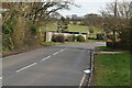
1
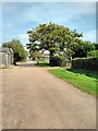
Sharnfold Cottages
Located on Hailsham Road, the B2104, opposite the turn off to Sharnfold farm shop.
Image: © Simon Carey
Taken: 21 Mar 2010
0.01 miles
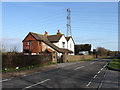
2
1066 Country Walk entering Sharnfold Farm
Image: © Dave Spicer
Taken: 9 Mar 2013
0.03 miles
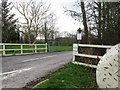
3
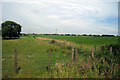
Warren Field
The name of the field according to the 1838 tithe map.
Image: © Simon Carey
Taken: 21 Mar 2010
0.06 miles
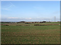
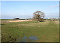
6
Cow Field Brooks
The name of the field according to the 1838 tithe map. Any field with brooks in it usually occupies a place next to low lying wet ground.
Image: © Simon Carey
Taken: 21 Mar 2010
0.16 miles
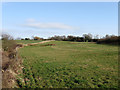
7
Six Roads
The name of the field according to the 1838 tithe map. The line of reeds to the left mark the course of Drockmill Hill Gut whilst the hamlet of Hankham can be seen in the distance on higher ground.
Image: © Simon Carey
Taken: 21 Mar 2010
0.17 miles
8
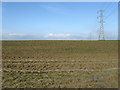
Hawth Down
The name of this section of the field according to the 1838 tithe map that has been enlarged to include Barn Field Meadow, Four Acres, Ten Acres, Clover Field and Twelve Acres.
Image: © Simon Carey
Taken: 21 Mar 2010
0.18 miles
9
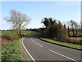
Hailsham Road
The B2104 as it crosses Drockmill Hill Gut the only clue being the white fence to the right. Sharnfold Cottages are in the distance.
Image: © Simon Carey
Taken: 21 Mar 2010
0.19 miles