IMAGES TAKEN NEAR TO
Cottage Lane, PEVENSEY, BN24 5BP
Introduction
This page details the photographs taken nearby to Cottage Lane, BN24 5BP by members of the Geograph project.
The Geograph project started in 2005 with the aim of publishing, organising and preserving representative images for every square kilometre of Great Britain, Ireland and the Isle of Man.

There are currently over 7.5m images from over14,400 individuals and you can help contribute to the project by visiting https://www.geograph.org.uk
Image Map
Images are licensed for reuse under creativecommons.org/licenses/by-sa/2.0
Notes
- Clicking on the map will re-center to the selected point.
- The higher the marker number, the further away the image location is from the centre of the postcode.
Image Listing (20 Images Found)
Images are licensed for reuse under creativecommons.org/licenses/by-sa/2.0
Image
Details
Distance
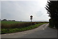
1
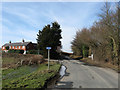
Glynleigh Road
Looking towards the junction with Cottage Lane with Glynleigh Cottages to the left.
Image: © Simon Carey
Taken: 20 Feb 2010
0.00 miles
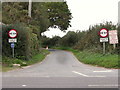
2
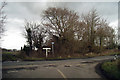
Junction of Glynleigh Road & Cottage Lane
Image: © Oast House Archive
Taken: 14 Feb 2009
0.01 miles
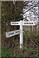
4
Direction Sign - Signpost by Glynleigh Road, Westham parish
Black iron cap finial - 3 arms; East Sussex wood by the UC road, in parish of Westham (Wealden District), Glynleigh Road, on verge opposite junction of Cottage Lane with Glynleigh Road.
Surveyed
Milestone Society National ID: SX_TQ6006
Image: © Milestone Society
Taken: Unknown
0.02 miles
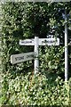
5
Cottage Lane
Junction with Glynleigh Road
Image: © Julian P Guffogg
Taken: 2 Apr 2011
0.03 miles
6
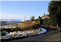
Cottage Lane, Hankham
This short road runs from Glyndleigh Road (where this photo was taken) through to Hailsham Road.
Image: © Kevin Gordon
Taken: 4 Feb 2009
0.05 miles
7
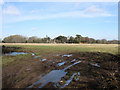
Old Woman's Field
The name of the field according to the 1838 tithe map. The trees in the distance mask the site of Glyndley Manor from the road through parts of Glyndley Manor Cottage Estate, a small close of holiday homes, can be seen to the right.
Image: © Simon Carey
Taken: 20 Feb 2010
0.12 miles
8
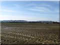
Kiln Field
The name of the field according to the 1838 tithe map. The South Downs can be seen in the distance with Combe Hill and Willingdon Hill on the left and Folkington Hill and Wilmington Hill to the right.
Image: © Simon Carey
Taken: 20 Feb 2010
0.13 miles
9
Cottage Lane, north of Stone Cross, East Sussex
Image: © nick macneill
Taken: 14 Oct 2010
0.14 miles
10
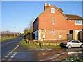
Old Court Cottage, Hankham
The road on the left is the B2104 Hailsham Road. The car on the right is parked in Cottage Lane
Image: © Kevin Gordon
Taken: 4 Feb 2009
0.15 miles