IMAGES TAKEN NEAR TO
Hankham Hall Road, PEVENSEY, BN24 5AQ
Introduction
This page details the photographs taken nearby to Hankham Hall Road, BN24 5AQ by members of the Geograph project.
The Geograph project started in 2005 with the aim of publishing, organising and preserving representative images for every square kilometre of Great Britain, Ireland and the Isle of Man.

There are currently over 7.5m images from over14,400 individuals and you can help contribute to the project by visiting https://www.geograph.org.uk
Image Map
Images are licensed for reuse under creativecommons.org/licenses/by-sa/2.0
Notes
- Clicking on the map will re-center to the selected point.
- The higher the marker number, the further away the image location is from the centre of the postcode.
Image Listing (17 Images Found)
Images are licensed for reuse under creativecommons.org/licenses/by-sa/2.0
Image
Details
Distance
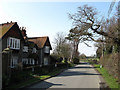
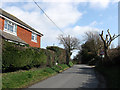
1
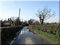
Hankham Hall Road
Narrow lane that runs between Ketchem Corner in Westham to the hamlet of Hankham. The houses in view are The Croft to the left and Marling Close beyond.
Image: © Simon Carey
Taken: 21 Mar 2010
0.01 miles
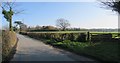
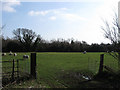
3
Nine Acres
The name of the field according to the 1838 tithe map. Part of the field has been lost to the house and grounds of Hankham Lodge.
Image: © Simon Carey
Taken: 21 Mar 2010
0.06 miles
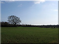
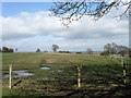
4
Wood Plot
The name of the field according to the 1838 tithe map. Beyond the hedge the field drops down onto Pevensey Levels which can be seen beyond.
Image: © Simon Carey
Taken: 21 Mar 2010
0.07 miles
5
Hankham Lodge
Late Victorian/Early Edwardian house that is now a residential care home.
Image: © Simon Carey
Taken: 21 Mar 2010
0.08 miles
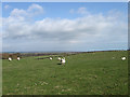
6
The Croft
The name of the field according to the 1838 tithe map. The hedgerow at the end of the field marks the course of Hankham Hall Road.
Image: © Simon Carey
Taken: 21 Mar 2010
0.11 miles
7
The Millers Croft
The name of the field according to the 1838 tithe map and as the name suggests located near to Westham windmill (Also known as Hankham, Crisfords and Black Mill) which existed between the mid 18th century and 1881 when it was blown down in a gale.
Image: © Simon Carey
Taken: 21 Mar 2010
0.11 miles
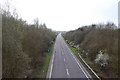
9
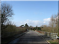
Bridge, Hankham Hall Road
Carrying the minor road to Hankham over the Pevensey By-Pass.
Image: © Simon Carey
Taken: 21 Mar 2010
0.16 miles
10
Hankham Mill Cottage
Nineteenth century cottage on Hankham Hall Road. As the name suggests a windmill was located to its rear until blown down in a gale in 1881.
Image: © Simon Carey
Taken: 21 Mar 2010
0.22 miles