IMAGES TAKEN NEAR TO
Hankham Hall Road, PEVENSEY, BN24 5AJ
Introduction
This page details the photographs taken nearby to Hankham Hall Road, BN24 5AJ by members of the Geograph project.
The Geograph project started in 2005 with the aim of publishing, organising and preserving representative images for every square kilometre of Great Britain, Ireland and the Isle of Man.

There are currently over 7.5m images from over14,400 individuals and you can help contribute to the project by visiting https://www.geograph.org.uk
Image Map
Images are licensed for reuse under creativecommons.org/licenses/by-sa/2.0
Notes
- Clicking on the map will re-center to the selected point.
- The higher the marker number, the further away the image location is from the centre of the postcode.
Image Listing (33 Images Found)
Images are licensed for reuse under creativecommons.org/licenses/by-sa/2.0
Image
Details
Distance
1
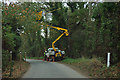
Overhead line work, Jenkins Green
Yellow protective sheathing seems to be being installed. These are probably phone lines.
Image: © Robin Webster
Taken: 15 Nov 2011
0.02 miles
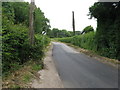
2
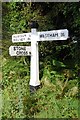
Direction Sign - Signpost at Jenkins' Green
Black iron cap finial - 3 arms; East Sussex wood by the UC road, in parish of Westham (Wealden District), Hankham Hall Road, on verge opposite junction of Foords Lane with Hankham Hall Road.
Surveyed
Milestone Society National ID: SX_TQ6205
Image: © Milestone Society
Taken: Unknown
0.04 miles
3
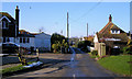
Foord's Lane, Hankham
Foords Lane runs from Hankham Hall Road to Hankham Street. This view is taken from the east end of the lane at its junction with Hankham Hall Road. this area is called Jenkin's Green. The house on the right is the Grade II listed Foord's Cottage dating from the 18th Century. Foord is an old Sussex name.
Image: © Kevin Gordon
Taken: 4 Feb 2009
0.05 miles
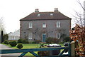
4
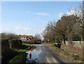
Hankham Hall Road
A bit of localised flooding in the foreground which was calf deep in places. The house is Pinhal and stands at a sort of crossroads with the entrance to Montague on the right and another to Hankham Nurseries beyond.
Image: © Simon Carey
Taken: 21 Mar 2010
0.07 miles
7
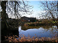
Pond, Hankham Hall Farm
Looking west from the road to some of the outbuildings of the farm.
Image: © Simon Carey
Taken: 21 Jan 2006
0.11 miles
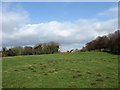
8
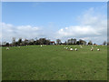
Barn Field
The name of the field according to the 1838 tithe map. The house at the far end of the field is Montague.
Image: © Simon Carey
Taken: 21 Mar 2010
0.12 miles
9
House Field
The name of the field according to the 1838 tithe map. A barn and oasthouse in the grounds of Montague can be seen at the top of the hill. In the foreground the moles have certainly been busy.
Image: © Simon Carey
Taken: 21 Mar 2010
0.12 miles
10
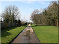
Drive to Hankham Nurseries
The drive is also a footpath that runs parallel to Hankham Street to the east of the village street.
Image: © Simon Carey
Taken: 21 Mar 2010
0.14 miles