IMAGES TAKEN NEAR TO
Crescent Road, BRIGHTON, BN2 3RP
Introduction
This page details the photographs taken nearby to Crescent Road, BN2 3RP by members of the Geograph project.
The Geograph project started in 2005 with the aim of publishing, organising and preserving representative images for every square kilometre of Great Britain, Ireland and the Isle of Man.

There are currently over 7.5m images from over14,400 individuals and you can help contribute to the project by visiting https://www.geograph.org.uk
Image Map
Images are licensed for reuse under creativecommons.org/licenses/by-sa/2.0
Notes
- Clicking on the map will re-center to the selected point.
- The higher the marker number, the further away the image location is from the centre of the postcode.
Image Listing (211 Images Found)
Images are licensed for reuse under creativecommons.org/licenses/by-sa/2.0
Image
Details
Distance
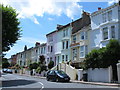
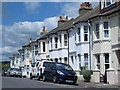
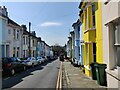
1
Crescent Road, Round Hill, Brighton
A residential road that runs between Princes crescent and Princes Road that was developed in the early 1880s with much of the rest of the estate.
Image: © Simon Carey
Taken: 11 Oct 2015
0.02 miles
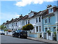
5
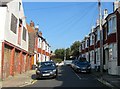
Belton Road, Round Hill, Brighton
This section of Belton Road to the north of the junction with Round Hill Road was built around 1914 on the former site of Round Hill Windmill. The tower mill had been built in 1838 and continued working until 1910 and was demolished in 1913 with the bricks recycled and used in the houses that replaced both the mill and its outbuildings. The last owners were the Cuttress family who acquired it in 1880 and would later go on to set up Forfars Bakery, a local chain that is still in existence today. See http://regencysociety-jamesgray.com/volume20/source/jg_20_075.htm for an image taken around 1893 with the mill located on the spot now occupied by the four terraced houses on the right. See also Image
Image: © Simon Carey
Taken: 11 Oct 2015
0.04 miles
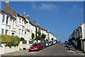
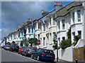
8
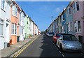
Belton Road, Round Hill, Brighton
A residential road that heads north from Princes Crescent and was developed in the early 1890s with the exception of the northern tip that was added around 1914, see Image Next to the green house on the left is the entrance to Image
Image: © Simon Carey
Taken: 11 Oct 2015
0.05 miles