IMAGES TAKEN NEAR TO
Princes Crescent, BRIGHTON, BN2 3RA
Introduction
This page details the photographs taken nearby to Princes Crescent, BN2 3RA by members of the Geograph project.
The Geograph project started in 2005 with the aim of publishing, organising and preserving representative images for every square kilometre of Great Britain, Ireland and the Isle of Man.

There are currently over 7.5m images from over14,400 individuals and you can help contribute to the project by visiting https://www.geograph.org.uk
Image Map
Images are licensed for reuse under creativecommons.org/licenses/by-sa/2.0
Notes
- Clicking on the map will re-center to the selected point.
- The higher the marker number, the further away the image location is from the centre of the postcode.
Image Listing (224 Images Found)
Images are licensed for reuse under creativecommons.org/licenses/by-sa/2.0
Image
Details
Distance
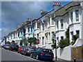
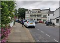
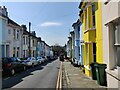
1
Princes Crescent, Round Hill, Brighton
A residential road that runs from Ditchling Road to Richmond Road that was developed in the early 1880s. To the south of the road was once a number of villas in extensive grounds that were all redeveloped in the 1950s.
Image: © Simon Carey
Taken: 11 Oct 2015
0.02 miles
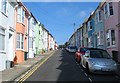
3
Belton Close, Round Hill, Brighton
A small cul de sac off Belton Road that was built on a small site that had originally been a nursery and was later a set of garages. The close contains five houses.
Image: © Simon Carey
Taken: 11 Oct 2015
0.03 miles
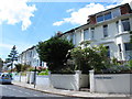
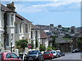
4
Crescent Mansions on Princes Crescent
Round Hill is an inner city suburban area of Brighton. It was developed mostly in the late 19th century on an area of high land overlooking central Brighton, and contains a mix of privately owned and privately rented terraced housing. Round Hill included a windmill, which stood on the 223-foot (68 m) hilltop until 1913.
Image: © Mat Fascione
Taken: 28 Jun 2024
0.03 miles
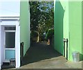
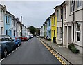
5
Belton Road, Round Hill, Brighton
A residential road that heads north from Princes Crescent and was developed in the early 1890s with the exception of the northern tip that was added around 1914, see Image Next to the green house on the left is the entrance to Image
Image: © Simon Carey
Taken: 11 Oct 2015
0.04 miles
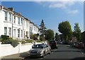
9
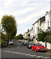
Princes Crescent, Round Hill, Brighton
Viewed from the junction with Wakefield Road and Richmond Road. Developed in the early 1880s the residential street runs in an arc westwards to Ditchling Road. On the left obscured by the trees is part of what was known as the Sylvan Hall estate built in the 1950s on the grounds of four large Victorian villas.
Image: © Simon Carey
Taken: 25 Oct 2015
0.05 miles