IMAGES TAKEN NEAR TO
Whippingham Road, BRIGHTON, BN2 3PZ
Introduction
This page details the photographs taken nearby to Whippingham Road, BN2 3PZ by members of the Geograph project.
The Geograph project started in 2005 with the aim of publishing, organising and preserving representative images for every square kilometre of Great Britain, Ireland and the Isle of Man.

There are currently over 7.5m images from over14,400 individuals and you can help contribute to the project by visiting https://www.geograph.org.uk
Image Map
Images are licensed for reuse under creativecommons.org/licenses/by-sa/2.0
Notes
- Clicking on the map will re-center to the selected point.
- The higher the marker number, the further away the image location is from the centre of the postcode.
Image Listing (158 Images Found)
Images are licensed for reuse under creativecommons.org/licenses/by-sa/2.0
Image
Details
Distance
1
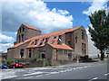
(The former) St. Wilfrid's Church, Elm Grove / Whippingham Road, BN2
The Wiki entry http://en.wikipedia.org/wiki/St_Wilfrid's_Church,_Brighton says that St Wilfrid's Church is a former Anglican church. Designed and built in the 1930s to replace a temporary building in the densely populated Elm Grove area, its unusual design — not conforming with architectural norms of the era — was widely praised. It was declared redundant after less than 50 years as a place of worship, and was converted into sheltered housing with minimal alteration to the exterior. Shortly after its closure, it was granted Grade II listed status http://list.english-heritage.org.uk/resultsingle.aspx?uid=1380499 .
Image: © Mike Quinn
Taken: 25 Jun 2014
0.00 miles
2
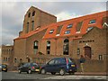
St Wilfrid's Flats
Built on the site of a former anglican church, the church was originalkly built in 1932 and was described by Sir John Betjement as £about the best 1930s church there is". To reflect this architectural merit it was eventually listed Grade II.
It was not known at the time the Church was built in 1932, that the blue asbestos used in the ceiling would become a health hazard. Due to the many problems with the building, which arose in later years, it was decided that St Wilfrid's would be closed despite vigorous petitions from the Parish and beyond. A public enquiry was held over its future. The Church Commissioners dropped a plan to demolish it following the inspector's recommendation and it was converted into sheltered housing for the elderly. The closing service of Thanksgiving was held in 1980 http://www.mybrightonandhove.org.uk/page_id__6594_path__0p115p187p951p.aspx
Image: © Paul Gillett
Taken: 25 Nov 2010
0.02 miles
3
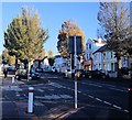
Elm Trees in Elm Grove
Viewed from the junction with Bonchurch Road
Image: © Paul Gillett
Taken: 2 Nov 2012
0.03 miles
4
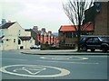
20mph speed limit - Elm Grove
The controversial speed limits come into effect in April 2013 across Brighton & Hove http://www.brighton-hove.gov.uk/index.cfm?request=c1266374
Image: © Paul Gillett
Taken: 30 Mar 2013
0.03 miles
8
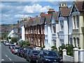
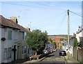
Lynton Street, Brighton
A residential road that runs between Queen's Park Road and Elm Grove that was developed in the early 1880s. Hollingbury Castle can be seen on the Downs in the distance.
Image: © Simon Carey
Taken: 25 Oct 2015
0.05 miles
9
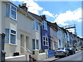
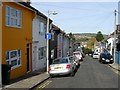
Baxter Street, Brighton
A residential street that runs between Queen's Park Road and Elm Grove that was developed in the early 1880s. The former St Wilfrid's church can be seen at the far end of the street.
Image: © Simon Carey
Taken: 25 Oct 2015
0.05 miles
10
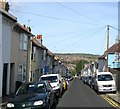
Cromwell Street, Brighton
The street originally ran between Queen's Park Road and Elm Grove but has now been blocked at the latter's end. Built in the early 1880s. Hollingbury Castle can be seen in the distance.
Image: © Simon Carey
Taken: 25 Oct 2015
0.05 miles