IMAGES TAKEN NEAR TO
St. Pauls Street, BRIGHTON, BN2 3HR
Introduction
This page details the photographs taken nearby to St. Pauls Street, BN2 3HR by members of the Geograph project.
The Geograph project started in 2005 with the aim of publishing, organising and preserving representative images for every square kilometre of Great Britain, Ireland and the Isle of Man.

There are currently over 7.5m images from over14,400 individuals and you can help contribute to the project by visiting https://www.geograph.org.uk
Image Map
Images are licensed for reuse under creativecommons.org/licenses/by-sa/2.0
Notes
- Clicking on the map will re-center to the selected point.
- The higher the marker number, the further away the image location is from the centre of the postcode.
Image Listing (224 Images Found)
Images are licensed for reuse under creativecommons.org/licenses/by-sa/2.0
Image
Details
Distance
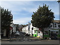
1
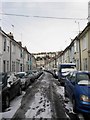
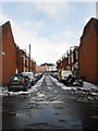
St Paul's Street
A side street that was developed in the 1860s and lies between Lewes Road and Upper Lewes Road. the houses beyond are part of the Round Hill suburb built on the hill of the same name.
Image: © Simon Carey
Taken: 12 Mar 2013
0.01 miles
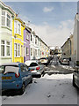
2
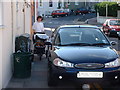
Obstruction!
Brighton's Victorian streets are very crowded. The need for the pavement bollards at the entrance to Round Hill Crescent (rear of picture) is amply demonstrated by this Ford driver's need to think about other car drivers, and no one else.
Image: © David Hodd
Taken: 1 Jul 2001
0.03 miles
3
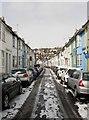
St Mary Magdalene Street
A side street that was developed in the 1860s and lies between Lewes Road and Upper Lewes Road. the houses beyond are part of the Round Hill suburb built on the hill of the same name.
Image: © Simon Carey
Taken: 12 Mar 2013
0.04 miles
4
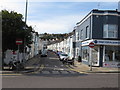
St. Paul's Street, Brighton
St. Paul's Street is a residential street in Brighton. No entry signs indicate that the street is one way only for vehicles.
Image: © Malc McDonald
Taken: 24 Aug 2019
0.05 miles
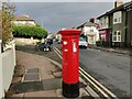
5
St. Martin's Street, Brighton
St. Martin's Street is a residential one-way street in Brighton.
Image: © Malc McDonald
Taken: 24 Aug 2019
0.06 miles
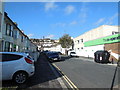
6
Brewer Street
Built in the 1880s on the site of a former 19th attraction known as The Maze the street runs from a dead end behind the photographer northwards to St Martins Street. To the right is the junction with Image
Image: © Simon Carey
Taken: 12 Mar 2013
0.06 miles
7
Caledonian Road, Brighton
Road leading from Lewes Road (by the co-op) to Upper Lewes Road. with Roundhill Terrace in the background
Image: © Paul Gillett
Taken: 2 Nov 2013
0.06 miles
9
Newport Street
A cul de sac that is located off Image and was built in the 1880s on the site of an old garden attached to the nearby Park Crescent estate.
Image: © Simon Carey
Taken: 12 Mar 2013
0.07 miles
10
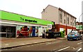
Co-op mini-market, Lewes Road, Brighton
Image: © nick macneill
Taken: 9 Mar 2012
0.08 miles