IMAGES TAKEN NEAR TO
Newport Street, BRIGHTON, BN2 3HL
Introduction
This page details the photographs taken nearby to Newport Street, BN2 3HL by members of the Geograph project.
The Geograph project started in 2005 with the aim of publishing, organising and preserving representative images for every square kilometre of Great Britain, Ireland and the Isle of Man.

There are currently over 7.5m images from over14,400 individuals and you can help contribute to the project by visiting https://www.geograph.org.uk
Image Map
Images are licensed for reuse under creativecommons.org/licenses/by-sa/2.0
Notes
- Clicking on the map will re-center to the selected point.
- The higher the marker number, the further away the image location is from the centre of the postcode.
Image Listing (211 Images Found)
Images are licensed for reuse under creativecommons.org/licenses/by-sa/2.0
Image
Details
Distance
1
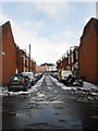
Newport Street
A cul de sac that is located off Image and was built in the 1880s on the site of an old garden attached to the nearby Park Crescent estate.
Image: © Simon Carey
Taken: 12 Mar 2013
0.00 miles
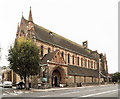
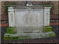
3
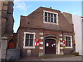
Wagner Memorial Hall, Lewes Road
Also see http://www.mybrightonandhove.org.uk/page_id__8206.aspx
Image: © Basher Eyre
Taken: 19 Dec 2014
0.02 miles
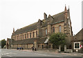
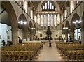
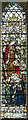
9
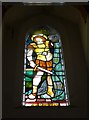
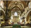
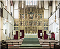
St Martin, Brighton: stained glass window
Image: © Basher Eyre
Taken: 19 Dec 2014
0.02 miles