IMAGES TAKEN NEAR TO
Union Road, BRIGHTON, BN2 3FX
Introduction
This page details the photographs taken nearby to Union Road, BN2 3FX by members of the Geograph project.
The Geograph project started in 2005 with the aim of publishing, organising and preserving representative images for every square kilometre of Great Britain, Ireland and the Isle of Man.

There are currently over 7.5m images from over14,400 individuals and you can help contribute to the project by visiting https://www.geograph.org.uk
Image Map
Images are licensed for reuse under creativecommons.org/licenses/by-sa/2.0
Notes
- Clicking on the map will re-center to the selected point.
- The higher the marker number, the further away the image location is from the centre of the postcode.
Image Listing (381 Images Found)
Images are licensed for reuse under creativecommons.org/licenses/by-sa/2.0
Image
Details
Distance
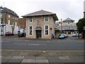
2
Salvation Army Citadel
Situated north of The Level
Image: © Paul Gillett
Taken: 25 Oct 2009
0.01 miles
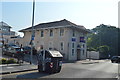
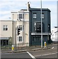
4
Bradbury's Coffee House, Union Road
Wedged between Park Crescent Terrace to the right and Rose Hill to the left. The Salvation Army Congress Hall is in the former and was built in 2000 to replace the former Congress Hall on the same site from 1883. Union Road links Lewes Road (A270) to Ditchling Road, an early main road to north Sussex and London.
Image: © Simon Carey
Taken: 24 Mar 2007
0.03 miles
5
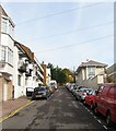
Rose Hill, Brighton
A residential street that links Union Road to Upper Lewes Road that was originally developed in the 1830s though parts have been replaced. On the left Button Court built in the 1960s replaced numbers 6-8 whilst on the right is the Salvation Army Congress Hall built in 2000 to replace an older 1883 building.
Image: © Simon Carey
Taken: 25 Oct 2015
0.04 miles
6
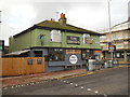
The Druids Pub
Opposite the level in Ditchling Road http://druidspub.com/
Image: © Paul Gillett
Taken: 14 Nov 2014
0.04 miles
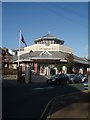
7
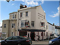
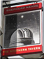
The Northern Tavern, Brighton
A Shepherd Neame pub on Ditchling Road.
Image: © Oast House Archive
Taken: 16 Oct 2010
0.04 miles
9
83-85, Ditchling Road, Brighton
Number 83 is on the left and is part of Cycle Wand shop that is located on the corner of Baker Street. Number 85 is on the grey building on the right and is currently a mortgage advisor. It was previously the Northern Star public house which operated from the 1840s until closure in 2013.
Image: © Simon Carey
Taken: 25 Oct 2015
0.04 miles
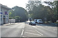
10
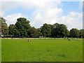
The Level, Brighton
Since its redesign in 2013 the northern part of the park is now open space and the former gravelled area on the western side has been turfed over, see Image
Image: © Simon Carey
Taken: 4 Oct 2015
0.04 miles