IMAGES TAKEN NEAR TO
Princes Road, BRIGHTON, BN2 3BY
Introduction
This page details the photographs taken nearby to Princes Road, BN2 3BY by members of the Geograph project.
The Geograph project started in 2005 with the aim of publishing, organising and preserving representative images for every square kilometre of Great Britain, Ireland and the Isle of Man.

There are currently over 7.5m images from over14,400 individuals and you can help contribute to the project by visiting https://www.geograph.org.uk
Image Map
Images are licensed for reuse under creativecommons.org/licenses/by-sa/2.0
Notes
- Clicking on the map will re-center to the selected point.
- The higher the marker number, the further away the image location is from the centre of the postcode.
Image Listing (196 Images Found)
Images are licensed for reuse under creativecommons.org/licenses/by-sa/2.0
Image
Details
Distance
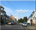
2
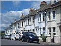
Princes Road, Round Hill, Brighton
A residential road that runs from Ditchling Road to the corner in the distance where it becomes Image It was developed in the early 1880s and ascends then descends the brow of Round Hill opening up the view towards Bevendean at this point.
Image: © Simon Carey
Taken: 11 Oct 2015
0.04 miles
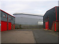
3
R & B Motors, Hughes Road, Centenary Industrial Estate
The industrial estate was built in 1986 on the site of the former Kemp Town branch railway that had operated between 1869 and 1971. The railway left the East Coastway line just out of shot to the right travelled over Lewes Road and Melbourne Road on a viaduct, Hartington Road by a smaller viaduct before tunnelling underneath the Hanover district and reaching its destination in Eastern Road. It was closed to the public in 1932 but retained its goods service until its closure. Part of the viaduct was removed in 1975 whilst the western half remained until 1983. A signal box behind this business unit remained until the late 1980s.
Image: © Simon Carey
Taken: 25 Dec 2008
0.05 miles
4
Centenary Industrial Estate
See Image for a full history of the site built on the former Kemp Town branch railway. The current East Coastway line is beyond the fence whilst the unit on the far side is a recently erected building constructed on the site of a former council depot and municipal abattoir.
Image: © Simon Carey
Taken: 25 Dec 2008
0.05 miles
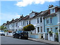
5
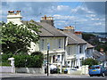
Mayo Road, Round Hill, Brighton
A residential road that runs north from Richmond road then turns west as Image It was developed in the 1880s though only the eastern and north western side remains. On the left is Mayo Court built on the site of Mayo Laundry which closed sometime in the 1970s.
Image: © Simon Carey
Taken: 11 Oct 2015
0.05 miles
7

Insect on the Waste Transfer Station, Hollingdean Lane, BN1
One of three - see Image
Image: © Mike Quinn
Taken: 25 Jun 2014
0.06 miles
8
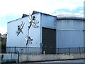
Waste Transfer Station, Hollingdean Lane, BN1
Shows the location of Image
Image: © Mike Quinn
Taken: 25 Jun 2014
0.06 miles
9
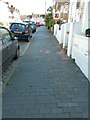
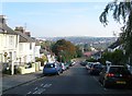
A rare black brick pavement on Mayo Road, Brighton
Mainly original black bricks form the pavement built with the houses at the end of the 19th century. The kerbstones and gutter setts are igneous diorite brought from Guernsey.
Image: © Robert Stephenson
Taken: 19 Sep 2011
0.06 miles