IMAGES TAKEN NEAR TO
Picton Street, BRIGHTON, BN2 3AP
Introduction
This page details the photographs taken nearby to Picton Street, BN2 3AP by members of the Geograph project.
The Geograph project started in 2005 with the aim of publishing, organising and preserving representative images for every square kilometre of Great Britain, Ireland and the Isle of Man.

There are currently over 7.5m images from over14,400 individuals and you can help contribute to the project by visiting https://www.geograph.org.uk
Image Map
Images are licensed for reuse under creativecommons.org/licenses/by-sa/2.0
Notes
- Clicking on the map will re-center to the selected point.
- The higher the marker number, the further away the image location is from the centre of the postcode.
Image Listing (232 Images Found)
Images are licensed for reuse under creativecommons.org/licenses/by-sa/2.0
Image
Details
Distance
1

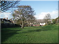
Picton Street, Brighton
A residential street off Franklin Road that was developed in the late 1870s. At its northern end is the entrance to William Clarke Park.
Image: © Simon Carey
Taken: 25 Oct 2015
0.01 miles
2
William Clarke Park
William Clarke Park sits on layers of landfill which during the 1970s was piled over the area where the rails of the old Kemp Town branch line had lain for the previous 100 years, It is situated between Elm Grove, Hartington Road and Bonchurch Road
http://www.williamclarkepark.org/
Image: © Paul Gillett
Taken: 15 Nov 2009
0.02 miles
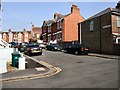
3

Coronation Street, Brighton
A small residential street that runs between Franklin Road and Seville Street that was developed around 1903 and celebrates the coronation of Edward VII.
Image: © Simon Carey
Taken: 25 Oct 2015
0.03 miles
4

Seville Street, Brighton
A residential street that heads south from Wellington Street before ending at the wall visible in the distance. Developed between 1903 and 1904
Image: © Simon Carey
Taken: 25 Oct 2015
0.03 miles
5
Coronation Street
No, not that one, this is a side street off of Franklin Road in Brighton
Image: © Paul Gillett
Taken: 18 Apr 2010
0.04 miles
6
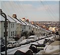
Snow in Bonchurch Road
The road runs between Elm Grove and Hartington Road
Image: © Paul Gillett
Taken: 18 Dec 2009
0.05 miles
7
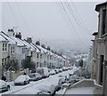
Snow in Bonchurch Road -Jan 2013
About 3 inches of snow has fallen
Image: © Paul Gillett
Taken: 18 Jan 2013
0.06 miles
8

William Clarke Park, Brighton
A small area of parkland that occupies the site of the dismantled Kemp Town Railway. Having crossed Hartington Road on a bridge the line headed south through a deep cutting to the northern portal of the Kemp Town Tunnel. Since the dismantling much of the cutting has been filled and landscaped into the park. The section in view was the rough location of Hartington Road Halt which opened in 1906 and closed in 1911. The original access path from Hartington Road to the station remains in use as an entrance to the park. In the distance is the suburb of Hollingdean with Hollingbury Castle on the peak to the right.
See also Image
Image: © Simon Carey
Taken: 25 Oct 2015
0.06 miles
9

Franklin Road, Brighton
A residential and arterial road that links Wellington Street to Lewes Road that was developed from the 1860s onwards. In the distance is the suburb of Round Hill, the large blocks of Image and to their right the suburb of Hollingdean.
Image: © Simon Carey
Taken: 25 Oct 2015
0.06 miles
10

William Clarke Park, Brighton
Occupying the site of the former Kemp Town railway. Having crossed Hartington Road on a bridge the line entered a deep cutting until it reached the northern portal of Kemp Town Tunnel. After the line's closure in 1971 much of the cutting has been used as landfill then landscaped into the park. Behind the photographer the park ends and becomes playgrounds for Elm Grove Junior School.
See also Image
Image: © Simon Carey
Taken: 25 Oct 2015
0.07 miles