IMAGES TAKEN NEAR TO
Briar Place, EASTBOURNE, BN23 8DB
Introduction
This page details the photographs taken nearby to Briar Place, BN23 8DB by members of the Geograph project.
The Geograph project started in 2005 with the aim of publishing, organising and preserving representative images for every square kilometre of Great Britain, Ireland and the Isle of Man.

There are currently over 7.5m images from over14,400 individuals and you can help contribute to the project by visiting https://www.geograph.org.uk
Image Map
Images are licensed for reuse under creativecommons.org/licenses/by-sa/2.0
Notes
- Clicking on the map will re-center to the selected point.
- The higher the marker number, the further away the image location is from the centre of the postcode.
Image Listing (15 Images Found)
Images are licensed for reuse under creativecommons.org/licenses/by-sa/2.0
Image
Details
Distance
2
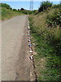
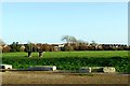
NHS Tribute stones
In Shinewater Park
The stones have been laid as a tribute to the NHS staff for their service and sacrifice during the Coronavirus pandemic
Image: © Paul Gillett
Taken: 24 Jun 2020
0.12 miles
4
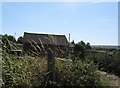
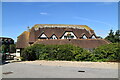
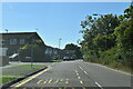
Southern Water monitoring building by Larkspur Drive Langney
Image: © Dave Spicer
Taken: 20 Aug 2013
0.15 miles
6
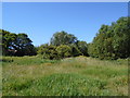
Playing field, Shinewater, Eastbourne
Image: © nick macneill
Taken: 30 Jan 2013
0.19 miles
8
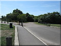
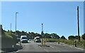
Entrance to Shinewater Park
The area is a small nature reserve surrounding Shinewater Lake.
Image: © Dave Spicer
Taken: 20 Aug 2013
0.20 miles