IMAGES TAKEN NEAR TO
Marsden Road, EASTBOURNE, BN23 7EE
Introduction
This page details the photographs taken nearby to Marsden Road, BN23 7EE by members of the Geograph project.
The Geograph project started in 2005 with the aim of publishing, organising and preserving representative images for every square kilometre of Great Britain, Ireland and the Isle of Man.

There are currently over 7.5m images from over14,400 individuals and you can help contribute to the project by visiting https://www.geograph.org.uk
Image Map
Images are licensed for reuse under creativecommons.org/licenses/by-sa/2.0
Notes
- Clicking on the map will re-center to the selected point.
- The higher the marker number, the further away the image location is from the centre of the postcode.
Image Listing (16 Images Found)
Images are licensed for reuse under creativecommons.org/licenses/by-sa/2.0
Image
Details
Distance
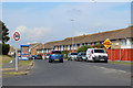
3
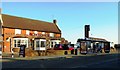
Martello public house and bus shelter, Langney, Eastbourne
Image: © nick macneill
Taken: 3 Feb 2012
0.19 miles
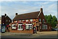
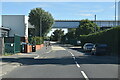
6
Langney Priory
A Grade II* Listed Building: https://britishlistedbuildings.co.uk/101043639-langney-priory-eastbourne#.XNL4q477RPZ
Image: © PAUL FARMER
Taken: 7 May 2019
0.20 miles

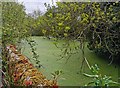
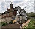
8
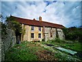
Langney Priory
A Grade II* Listed Building: https://britishlistedbuildings.co.uk/101043639-langney-priory-eastbourne#.XNL4q477RPZ
Image: © PAUL FARMER
Taken: 7 May 2019
0.21 miles