IMAGES TAKEN NEAR TO
Rotunda Road, EASTBOURNE, BN23 6LE
Introduction
This page details the photographs taken nearby to Rotunda Road, BN23 6LE by members of the Geograph project.
The Geograph project started in 2005 with the aim of publishing, organising and preserving representative images for every square kilometre of Great Britain, Ireland and the Isle of Man.

There are currently over 7.5m images from over14,400 individuals and you can help contribute to the project by visiting https://www.geograph.org.uk
Image Map
Images are licensed for reuse under creativecommons.org/licenses/by-sa/2.0
Notes
- Clicking on the map will re-center to the selected point.
- The higher the marker number, the further away the image location is from the centre of the postcode.
Image Listing (30 Images Found)
Images are licensed for reuse under creativecommons.org/licenses/by-sa/2.0
Image
Details
Distance
1
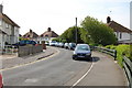
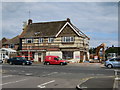
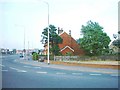
Rotunda Road, Eastbourne
This one-way road is indeed circular, and a smaller road (The Circus) is within the circle.
Image: © Julian P Guffogg
Taken: 1 May 2011
0.12 miles
2
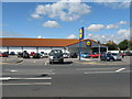
Lidl on the A259 at St Anthony's Hill Eastbourne
Image: © Dave Spicer
Taken: 18 Sep 2013
0.14 miles
3
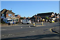
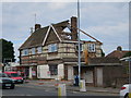
Site of former The Lodge pub
The pub was recently demolished to clear for a new development.
See during demolition Image
Image: © Oast House Archive
Taken: 3 Oct 2016
0.14 miles
4
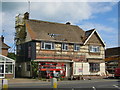
Demolition of The Lodge pub
The pub had closed years ago and the site abandoned.
The building is being deconstructed, revealing some of original facade which had been covered with black weatherboard in recent decades. The roof tiling was removed today.
Image: © Oast House Archive
Taken: 13 Jul 2016
0.15 miles
5
Demolition of The Lodge pub
The pub had closed years ago and the site abandoned.
The building is being deconstructed, revealing some of original facade which had been covered with black weatherboard in recent decades. The roof tiling was removed today.
Image: © Oast House Archive
Taken: 13 Jul 2016
0.15 miles
6
Demolition of The Lodge Inn pub
The Lodge or Lodge Inn pub had closed years ago and the site abandoned.
The building is being deconstructed, revealing some of original facade which had been covered with black weatherboard in recent decades. The roof tiling was removed today.
Image: © Oast House Archive
Taken: 13 Jul 2016
0.15 miles
8
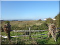
West Langney Level
This looks from Langley Rise (B2104) immediately south of Langney Bridge. The houses on the right are in Sevenoaks Road and Langney Sewer is to the right, just out of the picture. The South Downs around Combe Hill and Willingdon Hill are in the far distance.
Image: © Marathon
Taken: 21 Oct 2018
0.20 miles
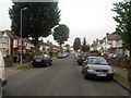
9
Pevensey Bay Road, Eastbourne
Looking East along Pevensey Bay Road, the photographer is standing on the 'Langney Roundabout'.
Image: © Jeff Wells
Taken: Unknown
0.20 miles
10
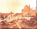
Pevensey Bay Road, Eastbourne
Now 4, 6 and 8 Pevensey Bay Road, these buildings were at the front of the dairy farm, at one time Simmons and Cowley Dairies. The small extension on the first house was a shop selling dairy produce.
Image: © Jeff Wells
Taken: Unknown
0.20 miles