IMAGES TAKEN NEAR TO
Schofield Way, EASTBOURNE, BN23 6HQ
Introduction
This page details the photographs taken nearby to Schofield Way, BN23 6HQ by members of the Geograph project.
The Geograph project started in 2005 with the aim of publishing, organising and preserving representative images for every square kilometre of Great Britain, Ireland and the Isle of Man.

There are currently over 7.5m images from over14,400 individuals and you can help contribute to the project by visiting https://www.geograph.org.uk
Image Map
Images are licensed for reuse under creativecommons.org/licenses/by-sa/2.0
Notes
- Clicking on the map will re-center to the selected point.
- The higher the marker number, the further away the image location is from the centre of the postcode.
Image Listing (88 Images Found)
Images are licensed for reuse under creativecommons.org/licenses/by-sa/2.0
Image
Details
Distance
1
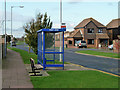
What bus stop is this?
The shelter says Hardy Drive: the sign says Columbus Drive. The stop is on Ramsay Way. Hardy Drive is a left turn close to this stop: Columbus Drive is a right turn further away.
Image: © Robin Webster
Taken: 17 Nov 2011
0.08 miles