IMAGES TAKEN NEAR TO
Tutts Barn Lane, EASTBOURNE, BN22 8XT
Introduction
This page details the photographs taken nearby to Tutts Barn Lane, BN22 8XT by members of the Geograph project.
The Geograph project started in 2005 with the aim of publishing, organising and preserving representative images for every square kilometre of Great Britain, Ireland and the Isle of Man.

There are currently over 7.5m images from over14,400 individuals and you can help contribute to the project by visiting https://www.geograph.org.uk
Image Map
Images are licensed for reuse under creativecommons.org/licenses/by-sa/2.0
Notes
- Clicking on the map will re-center to the selected point.
- The higher the marker number, the further away the image location is from the centre of the postcode.
Image Listing (15 Images Found)
Images are licensed for reuse under creativecommons.org/licenses/by-sa/2.0
Image
Details
Distance
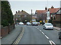
5
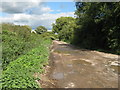
Tutts Barn Lane
Unmade lane that terminates by the Eastbourne Line.
Image: © Dave Spicer
Taken: 18 Sep 2013
0.15 miles
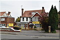
6
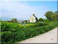
Upperton Farm, Eastbourne Level
Taken from Tutts Barn Lane.
Image: © Simon Carey
Taken: 2 Jun 2006
0.15 miles
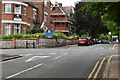
7
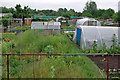
Gorringe Road Allotments
Probably the largest area of allotments in Eastbourne.
Image: © Robin Webster
Taken: 11 Jun 2010
0.16 miles