IMAGES TAKEN NEAR TO
Mayfield Place, EASTBOURNE, BN22 8XJ
Introduction
This page details the photographs taken nearby to Mayfield Place, BN22 8XJ by members of the Geograph project.
The Geograph project started in 2005 with the aim of publishing, organising and preserving representative images for every square kilometre of Great Britain, Ireland and the Isle of Man.

There are currently over 7.5m images from over14,400 individuals and you can help contribute to the project by visiting https://www.geograph.org.uk
Image Map
Images are licensed for reuse under creativecommons.org/licenses/by-sa/2.0
Notes
- Clicking on the map will re-center to the selected point.
- The higher the marker number, the further away the image location is from the centre of the postcode.
Image Listing (60 Images Found)
Images are licensed for reuse under creativecommons.org/licenses/by-sa/2.0
Image
Details
Distance
1
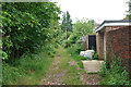
Track at back of houses on Mayfield Place
This looks as if a path at the far end of the track connects to the end of Mayfield Place, but a check on this was not carried out, as it would be tedious to retrace the route if there was no way through.
Image: © Robin Webster
Taken: 11 Jun 2010
0.04 miles
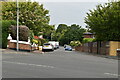

8
Entrance to Old Pump House, Eastbourne
This entrance is to the oldld Bedfordwell Waterworks Pumping Station.
Image: © PAUL FARMER
Taken: 6 Jun 2015
0.07 miles
9

Boarded up House, Bedfordwell Road, Eastbourne
Image: © PAUL FARMER
Taken: 22 May 2016
0.07 miles
10
![Eastbourne buildings [31]](https://s0.geograph.org.uk/geophotos/07/21/65/7216524_ceccbff4_120x120.jpg)
Eastbourne buildings [31]
Seen from Bedfordwell Road as the site is security fenced and due to have houses built thereon, is Bedfordwell Pumping Station. Built in 1883, the engine house and attached boiler house, in yellow brick with red brick dressings under a slate roof, are in the Classical style. Disused after 1895 when the well was contaminated, the buildings became part of a council depot. Listed, grade II, with much history and detail at: https://historicengland.org.uk/listing/the-list/list-entry/1418787
Eastbourne is a town and seaside resort on the south coast of East Sussex, some 54 miles south of London and about 19 miles east of Brighton. Although there is evidence of settlement from the Stone Age onwards, Eastbourne remained an area of small rural settlements until the railway arrived in 1849. A resort, built "for gentlemen by gentlemen", was planned and the town's growth accelerated from a population of less than 4,000 in 1851 to nearly 35,000 by 1891. Tourism is a large and important part of the economy of the town.
Image: © Michael Dibb
Taken: 10 May 2022
0.07 miles