IMAGES TAKEN NEAR TO
Brookmead Close, EASTBOURNE, BN22 8UX
Introduction
This page details the photographs taken nearby to Brookmead Close, BN22 8UX by members of the Geograph project.
The Geograph project started in 2005 with the aim of publishing, organising and preserving representative images for every square kilometre of Great Britain, Ireland and the Isle of Man.

There are currently over 7.5m images from over14,400 individuals and you can help contribute to the project by visiting https://www.geograph.org.uk
Image Map
Images are licensed for reuse under creativecommons.org/licenses/by-sa/2.0
Notes
- Clicking on the map will re-center to the selected point.
- The higher the marker number, the further away the image location is from the centre of the postcode.
Image Listing (13 Images Found)
Images are licensed for reuse under creativecommons.org/licenses/by-sa/2.0
Image
Details
Distance
1
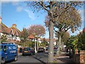
Moy Avenue
Autumnal trees at the eastern end of the residential road.
Image: © Oast House Archive
Taken: 18 Oct 2011
0.04 miles
3
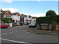
Annington Road junction with Ringwood Road Eastbourne
Image: © Dave Spicer
Taken: 18 Sep 2013
0.18 miles
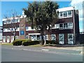
4
ESK Warehouses, Courtlands Road, Eastbourne
Image: © Oast House Archive
Taken: 3 May 2009
0.19 miles
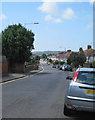
5
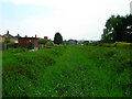
Horsey Sewer, Roselands
The backs of the houses of Moy Avenue are to the left whilst the buildings of Courtland Road industrial estate are straight ahead.
Image: © Simon Carey
Taken: 2 Jun 2006
0.19 miles
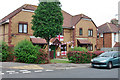
6
Charter House, Courtlands Road, Eastbourne
Image: © PAUL FARMER
Taken: 23 Aug 2014
0.21 miles
7
England supporter on Roselands Avenue
It was the 2010 World Cup.
Image: © Robin Webster
Taken: 11 Jun 2010
0.22 miles
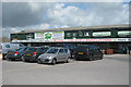
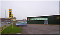
8
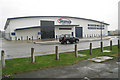
Builders Merchant on Courtlands Road
Image: © Oast House Archive
Taken: 10 Apr 2009
0.22 miles
9
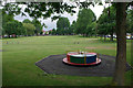
It's roundabout here
'Here' is a play area on The Lawns.
Image: © Robin Webster
Taken: 11 Jun 2010
0.22 miles
10
Pet Supply Shop, Courtlands Road, Eastbourne
Courtlands Road is named after Courtlands Marsh (part of the Southbourne Levels) on which the road is built.
Image: © Kevin Gordon
Taken: 3 Nov 2008
0.22 miles