IMAGES TAKEN NEAR TO
Badlesmere Road, EASTBOURNE, BN22 8TW
Introduction
This page details the photographs taken nearby to Badlesmere Road, BN22 8TW by members of the Geograph project.
The Geograph project started in 2005 with the aim of publishing, organising and preserving representative images for every square kilometre of Great Britain, Ireland and the Isle of Man.

There are currently over 7.5m images from over14,400 individuals and you can help contribute to the project by visiting https://www.geograph.org.uk
Image Map
Images are licensed for reuse under creativecommons.org/licenses/by-sa/2.0
Notes
- Clicking on the map will re-center to the selected point.
- The higher the marker number, the further away the image location is from the centre of the postcode.
Image Listing (15 Images Found)
Images are licensed for reuse under creativecommons.org/licenses/by-sa/2.0
Image
Details
Distance
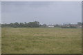
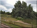
5
Miniature Railway track around Southbourne Lake
See from the railway into Eastbourne.
Image: © Stanley Howe
Taken: 15 May 2013
0.19 miles
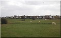
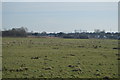
7
Horsye Road
This is named after a small island (Horse Isle) which once protruded from the nearby Southbourne Levels.
Image: © Kevin Gordon
Taken: 3 Nov 2008
0.20 miles
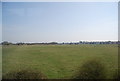
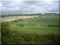
8
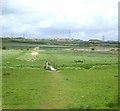
A footbridge over a drain
On a path across Southbourne Level.
Image: © Stanley Howe
Taken: 15 May 2013
0.20 miles