IMAGES TAKEN NEAR TO
Ringwood Road, EASTBOURNE, BN22 8TD
Introduction
This page details the photographs taken nearby to Ringwood Road, BN22 8TD by members of the Geograph project.
The Geograph project started in 2005 with the aim of publishing, organising and preserving representative images for every square kilometre of Great Britain, Ireland and the Isle of Man.

There are currently over 7.5m images from over14,400 individuals and you can help contribute to the project by visiting https://www.geograph.org.uk
Image Map
Images are licensed for reuse under creativecommons.org/licenses/by-sa/2.0
Notes
- Clicking on the map will re-center to the selected point.
- The higher the marker number, the further away the image location is from the centre of the postcode.
Image Listing (43 Images Found)
Images are licensed for reuse under creativecommons.org/licenses/by-sa/2.0
Image
Details
Distance
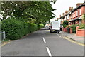
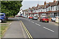
1
Annington Road junction with Ringwood Road Eastbourne
Image: © Dave Spicer
Taken: 18 Sep 2013
0.03 miles

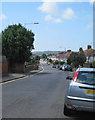
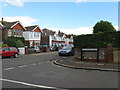
9
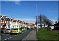
Whitley Road, Eastbourne, East Sussex
This road follows the route of an earlier road called Chawbrook Drove. It was renamed after Nicholas Whitley who was an agent to the Gilbert Estate. The road on the right is Kerrara Terrace. As I took the photo the ambulance car zoomed past with lights flashing en-route to an emergency.
Image: © Kevin Gordon
Taken: 13 Apr 2008
0.15 miles