IMAGES TAKEN NEAR TO
Moy Avenue, EASTBOURNE, BN22 8LD
Introduction
This page details the photographs taken nearby to Moy Avenue, BN22 8LD by members of the Geograph project.
The Geograph project started in 2005 with the aim of publishing, organising and preserving representative images for every square kilometre of Great Britain, Ireland and the Isle of Man.

There are currently over 7.5m images from over14,400 individuals and you can help contribute to the project by visiting https://www.geograph.org.uk
Image Map
Images are licensed for reuse under creativecommons.org/licenses/by-sa/2.0
Notes
- Clicking on the map will re-center to the selected point.
- The higher the marker number, the further away the image location is from the centre of the postcode.
Image Listing (43 Images Found)
Images are licensed for reuse under creativecommons.org/licenses/by-sa/2.0
Image
Details
Distance
2
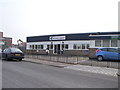
Suncoast Church, Eastbourne
The church belongs to the Christian Outreach Centre group of churches.
Image: © nick macneill
Taken: 29 Apr 2011
0.04 miles
3
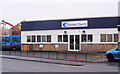
Suncoast Church, Courtlands Road, Eastbourne
The Suncoast Church is a Christian Outreach Centre.
Image: © Kevin Gordon
Taken: 3 Nov 2008
0.05 miles
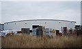
4
Moy Avenue
The large premises on the left are empty.
Image: © Robin Webster
Taken: 11 Jun 2010
0.05 miles
5
Empty premises on Moy Avenue
The lowest windows are boarded up, but the upper windows are just a stone's throw away.
Image: © Robin Webster
Taken: 11 Jun 2010
0.07 miles
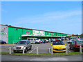
6
Pet Supply Shop, Courtlands Road, Eastbourne
Courtlands Road is named after Courtlands Marsh (part of the Southbourne Levels) on which the road is built.
Image: © Kevin Gordon
Taken: 3 Nov 2008
0.09 miles
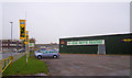
7
Esk Discount Warehouse, Courtlands Road
Purchased many (cheap) utensils here when I bought my first flat!
Image: © Simon Carey
Taken: 2 Jun 2006
0.10 miles
8
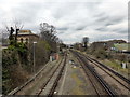
Railway line near Eastbourne
Picture taken from bridge taking A2021 over the track
Image: © PAUL FARMER
Taken: 8 Mar 2016
0.10 miles

10
![Eastbourne buildings [31]](https://s0.geograph.org.uk/geophotos/07/21/65/7216524_ceccbff4_120x120.jpg)
Eastbourne buildings [31]
Seen from Bedfordwell Road as the site is security fenced and due to have houses built thereon, is Bedfordwell Pumping Station. Built in 1883, the engine house and attached boiler house, in yellow brick with red brick dressings under a slate roof, are in the Classical style. Disused after 1895 when the well was contaminated, the buildings became part of a council depot. Listed, grade II, with much history and detail at: https://historicengland.org.uk/listing/the-list/list-entry/1418787
Eastbourne is a town and seaside resort on the south coast of East Sussex, some 54 miles south of London and about 19 miles east of Brighton. Although there is evidence of settlement from the Stone Age onwards, Eastbourne remained an area of small rural settlements until the railway arrived in 1849. A resort, built "for gentlemen by gentlemen", was planned and the town's growth accelerated from a population of less than 4,000 in 1851 to nearly 35,000 by 1891. Tourism is a large and important part of the economy of the town.
Image: © Michael Dibb
Taken: 10 May 2022
0.11 miles