IMAGES TAKEN NEAR TO
Langney Road, EASTBOURNE, BN22 8AF
Introduction
This page details the photographs taken nearby to Langney Road, BN22 8AF by members of the Geograph project.
The Geograph project started in 2005 with the aim of publishing, organising and preserving representative images for every square kilometre of Great Britain, Ireland and the Isle of Man.

There are currently over 7.5m images from over14,400 individuals and you can help contribute to the project by visiting https://www.geograph.org.uk
Image Map
Images are licensed for reuse under creativecommons.org/licenses/by-sa/2.0
Notes
- Clicking on the map will re-center to the selected point.
- The higher the marker number, the further away the image location is from the centre of the postcode.
Image Listing (356 Images Found)
Images are licensed for reuse under creativecommons.org/licenses/by-sa/2.0
Image
Details
Distance
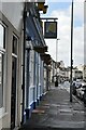
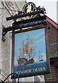
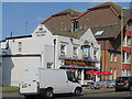
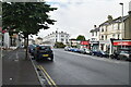
1
The Windsor Tavern
On Langney Road, Eastbourne. http://www.geograph.org.uk/photo/4808541
Image: © Ian S
Taken: 24 Jan 2016
0.01 miles
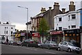
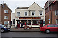
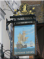
2
The Windsor Tavern
On Langney Road, Eastbourne. http://www.geograph.org.uk/photo/4808538
Image: © Ian S
Taken: 24 Jan 2016
0.01 miles
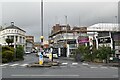
8
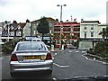
Junction of A259, Seaside, Eastbourne
Road Junction with A259 showing the Marine Public House opposite the junction
Image: © Christine Matthews
Taken: 14 Oct 2005
0.05 miles