IMAGES TAKEN NEAR TO
Swinburne Avenue, EASTBOURNE, BN22 0PN
Introduction
This page details the photographs taken nearby to Swinburne Avenue, BN22 0PN by members of the Geograph project.
The Geograph project started in 2005 with the aim of publishing, organising and preserving representative images for every square kilometre of Great Britain, Ireland and the Isle of Man.

There are currently over 7.5m images from over14,400 individuals and you can help contribute to the project by visiting https://www.geograph.org.uk
Image Map
Images are licensed for reuse under creativecommons.org/licenses/by-sa/2.0
Notes
- Clicking on the map will re-center to the selected point.
- The higher the marker number, the further away the image location is from the centre of the postcode.
Image Listing (5 Images Found)
Images are licensed for reuse under creativecommons.org/licenses/by-sa/2.0
Image
Details
Distance
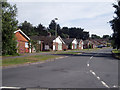
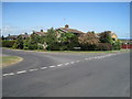
1
Towards the Downs from Seven Sisters Road
The road on the left of the picture is Swinburne Avenue at its intersection with Seven Sisters Road on the Hamlands Estate in Lower Willingdon.
Image: © Andrew Huggett
Taken: Unknown
0.04 miles
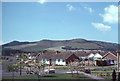
2
Seven Sisters Road, Lower Willingdon, Eastbourne
Image: © Julian P Guffogg
Taken: 20 May 2011
0.22 miles
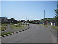
3
Junction of Winchester and Huggets Lane, Eastbourne
Image: © nick macneill
Taken: 29 Oct 2010
0.22 miles
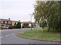
4
Junction of Huggett's Lane with The Freshway
Image: © Julian P Guffogg
Taken: 20 May 2011
0.24 miles