IMAGES TAKEN NEAR TO
Woodland Avenue, EASTBOURNE, BN22 0HE
Introduction
This page details the photographs taken nearby to Woodland Avenue, BN22 0HE by members of the Geograph project.
The Geograph project started in 2005 with the aim of publishing, organising and preserving representative images for every square kilometre of Great Britain, Ireland and the Isle of Man.

There are currently over 7.5m images from over14,400 individuals and you can help contribute to the project by visiting https://www.geograph.org.uk
Image Map
Images are licensed for reuse under creativecommons.org/licenses/by-sa/2.0
Notes
- Clicking on the map will re-center to the selected point.
- The higher the marker number, the further away the image location is from the centre of the postcode.
Image Listing (17 Images Found)
Images are licensed for reuse under creativecommons.org/licenses/by-sa/2.0
Image
Details
Distance
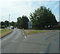
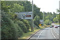
3
Roundabout, Willingdon Rd
The junction of the A2270 & A2021.
Image: © N Chadwick
Taken: 31 Mar 2011
0.14 miles
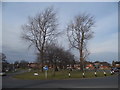
4
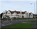
Sunrise Senior Living, Upper Kings Drive
Viewed from the other side of Willingdon Road, the A2270 before it reaches Willingdon Roundabout. Opened in 2008 on the site of a former garden centre the building is a purpose built residential home with its own hairdressers, bistro and communal areas.
Image: © Simon Carey
Taken: 24 Jan 2009
0.14 miles
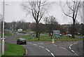
8
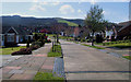
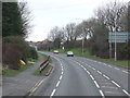
Wrestwood Avenue, Willingdon, East Sussex
With the South Downs in the background.
Image: © Kevin Gordon
Taken: 13 Apr 2008
0.16 miles
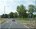
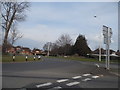
10
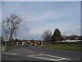
The Willingdon Roundabout from the southern approach
Image: © David Howard
Taken: 3 Apr 2016
0.17 miles