IMAGES TAKEN NEAR TO
Willingdon Park Drive, EASTBOURNE, BN22 0BS
Introduction
This page details the photographs taken nearby to Willingdon Park Drive, BN22 0BS by members of the Geograph project.
The Geograph project started in 2005 with the aim of publishing, organising and preserving representative images for every square kilometre of Great Britain, Ireland and the Isle of Man.

There are currently over 7.5m images from over14,400 individuals and you can help contribute to the project by visiting https://www.geograph.org.uk
Image Map
Images are licensed for reuse under creativecommons.org/licenses/by-sa/2.0
Notes
- Clicking on the map will re-center to the selected point.
- The higher the marker number, the further away the image location is from the centre of the postcode.
Image Listing (18 Images Found)
Images are licensed for reuse under creativecommons.org/licenses/by-sa/2.0
Image
Details
Distance
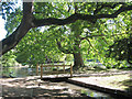
1

Willingdon Park Drive
A road beset with traffic calming measures. There is a remarkable inclined tree on the right, that seems to have found the vertical again in its upper part.
Image: © Robin Webster
Taken: 11 Sep 2011
0.02 miles
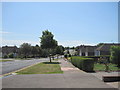
2

Willingdon Park Drive
A post war housing estate built in the area known as Lower Willingdon.
Image: © Simon Carey
Taken: 2 Jun 2006
0.08 miles
5

Pampas Grass by Hampden Park Drive
Image: © Oast House Archive
Taken: 15 Sep 2011
0.21 miles
7

Postbox, The Broadway, Lindfield Road, Hampden Park
Image: © PAUL FARMER
Taken: 20 Jan 2023
0.22 miles
8
Bridge at Hampden Park
Looking towards the main pond.
Image: © Oast House Archive
Taken: 15 Sep 2011
0.22 miles