IMAGES TAKEN NEAR TO
Chelworth Road, EASTBOURNE, BN22 0BD
Introduction
This page details the photographs taken nearby to Chelworth Road, BN22 0BD by members of the Geograph project.
The Geograph project started in 2005 with the aim of publishing, organising and preserving representative images for every square kilometre of Great Britain, Ireland and the Isle of Man.

There are currently over 7.5m images from over14,400 individuals and you can help contribute to the project by visiting https://www.geograph.org.uk
Image Map
Images are licensed for reuse under creativecommons.org/licenses/by-sa/2.0
Notes
- Clicking on the map will re-center to the selected point.
- The higher the marker number, the further away the image location is from the centre of the postcode.
Image Listing (8 Images Found)
Images are licensed for reuse under creativecommons.org/licenses/by-sa/2.0
Image
Details
Distance
2

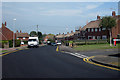
Solar panels on houses on Brodrick Road
Image: © Dave Spicer
Taken: 20 Aug 2013
0.10 miles
3

Postbox, The Broadway, Lindfield Road, Hampden Park
Image: © PAUL FARMER
Taken: 20 Jan 2023
0.16 miles


8

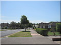
Friston Avenue, Willingdon, East Sussex
The turning for Wrestwood Avenue is on the right just by the letter box.
Image: © Kevin Gordon
Taken: 13 Apr 2008
0.22 miles