IMAGES TAKEN NEAR TO
Camelford Street, BRIGHTON, BN2 1WQ
Introduction
This page details the photographs taken nearby to Camelford Street, BN2 1WQ by members of the Geograph project.
The Geograph project started in 2005 with the aim of publishing, organising and preserving representative images for every square kilometre of Great Britain, Ireland and the Isle of Man.

There are currently over 7.5m images from over14,400 individuals and you can help contribute to the project by visiting https://www.geograph.org.uk
Image Map
Images are licensed for reuse under creativecommons.org/licenses/by-sa/2.0
Notes
- Clicking on the map will re-center to the selected point.
- The higher the marker number, the further away the image location is from the centre of the postcode.
Image Listing (1549 Images Found)
Images are licensed for reuse under creativecommons.org/licenses/by-sa/2.0
Image
Details
Distance
1
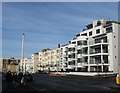
Van Alen Building, Marine Parade
Completed in 2001 on the site of a former petrol filling station, architecturally has echoes of 1930s modernism and fits in reasonably well with the surrounding Regency buildings.
Image: © Simon Carey
Taken: 11 Jan 2009
0.01 miles
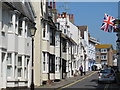
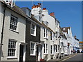
2
Camelford Street
Built up from the 1790s on a former piece of farmland known as Cliff Furlong. Originally known as York Street but changed in the early 19th century to its current name.
Image: © Simon Carey
Taken: 11 Jan 2009
0.01 miles
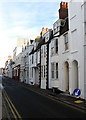
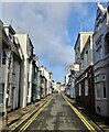
3

Camelford Street
A narrow street of what Pevsner in 1965 described as "real, entirely unselfconscious cottages", laid out in the late 18th century expansion of the town eastward from the Old Steine. Most of the premises are of two storeys plus basement and attic with dormer windows, but the central house in this view (no 17) has three full storeys complete with window bay. It was once the residence of the Prince Regent's bandmaster but after many years as a family home it has now found a new lease of life as a venue for Hen Parties.
For a summer view from the opposite direction see Marathon's photo Image
Image: © Tiger
Taken: 21 Jan 2020
0.01 miles

6
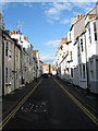
Camelford Street
A minor side street linking St James's Street to Marine Parade, the A259, that was developed in the 1780s as York Street its name becoming the current one by 1798.
Image: © Simon Carey
Taken: 7 Oct 2011
0.02 miles
7
Camelford Street, Brighton
Laid out in the late 19th century when it was originally known as York Street. It links Marine Parade, the A259, to St James's Street, the B2066.
Image: © Simon Carey
Taken: 2 Jan 2025
0.02 miles
9

The Camelford Arms, Camelford Street, BN2
Image: © Mike Quinn
Taken: 22 May 2012
0.02 miles
10

Sign for The Camelford Arms, Camelford Street, BN2
See Image
Image: © Mike Quinn
Taken: 22 May 2012
0.02 miles