1
Law Courts, Edward Street
Head north up Dorset Gardens then west down Edward Street to the junction with George Street. As mentioned before the northern parts of Edward Street were cleared between the 1930s and 1960s in order to remove some of the worst slums in the town. Part of the redevelopment included a new county court building designed by Percy Billington and opened in 1967.
Click on the link to take you to the next page. http://www.geograph.org.uk/photo/231486
Image: © Simon Carey
Taken: 1 Sep 2006
0.01 miles
2
Brighton Law Courts
Situated in Edward Street
See broader view
Image]
Image: © Paul Gillett
Taken: 16 May 2009
0.01 miles
3
The Jury's Out, Edward Street, Brighton
One of two pubs remaining on Edward Street where there were once 25. Dating from at least 1822 it was opened as the Thurlow Arms and changed to its current name sometime in the 1990s denoting its position opposite the law courts. Beyond is the northern end of George Street.
Image: © Simon Carey
Taken: 1 Nov 2015
0.01 miles
4
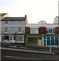
168-171, Edward Street, Brighton
Located on the southern side between Steine Gardens and Dorset Street. Edward Street was developed in the 1800s and was originally a narrow street climbing the hill to the cross roads with Park Street and Lavender Street where it became Eastern Road. All of the northern side was removed between the 1930s and 1960s and the road turned into a dual carriageway. The southern side still retains some of its original housing.
Image: © Simon Carey
Taken: 1 Nov 2015
0.03 miles
5
Brighton Law Courts
In Edward Street
Image: © Paul Gillett
Taken: 18 Jun 2011
0.03 miles
6
Brighton, Bierhaus
Good Beer Guide-listed public house on Edward Street; single room, back counter, drinking area left, front and right; TV, outside seating. Four cask ales were on offer at my visit, including three from Brighton Bier. Also the taproom for Brighton Bier: http://www.brighton.beer/
Image: © Mike Faherty
Taken: 22 Sep 2018
0.03 miles
7
Steine Gardens, Brighton
A cul de sac off Edward Street that was developed in the 1790s. Just in view on the right is Parochial Mews built on the site of the former Parochial Offices.
Image: © Simon Carey
Taken: 1 Nov 2015
0.04 miles
8
Little George Street, Brighton
Originally a small alley containing eleven cottages that were demolished in 1974. A couple were rebuilt in 1988 and retain the old numbering being 8-9. The current path leads to the car park behind Morrison's.
Image: © Simon Carey
Taken: 1 Nov 2015
0.05 miles
9
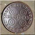
Coal plate, Dorset Gardens, Brighton
'A. Burstow & Co. Star Foundry Brighton'. The foundry was on Bread Street, with an official address on Church Street. It closed in the 1900s. In 1890 the proprietor was A. Burstow. A Star Foundry plate with another name is shown in
Image
Image: © Robin Webster
Taken: 19 Jul 2016
0.05 miles
10
Dorset Gardens
Head north from the junction of St James' Street and Madeira Place up Dorset Gardens. This development was built in the late 1790s and included a small park for the residents. The park itself became a public one from 1884. Numbers 12-18 Dorset Gardens are listed.
Click on the link to take you to the next page. http://www.geograph.org.uk/photo/231480
Image: © Simon Carey
Taken: 1 Sep 2006
0.05 miles


