IMAGES TAKEN NEAR TO
Pavilion Parade, BRIGHTON, BN2 1RY
Introduction
This page details the photographs taken nearby to Pavilion Parade, BN2 1RY by members of the Geograph project.
The Geograph project started in 2005 with the aim of publishing, organising and preserving representative images for every square kilometre of Great Britain, Ireland and the Isle of Man.

There are currently over 7.5m images from over14,400 individuals and you can help contribute to the project by visiting https://www.geograph.org.uk
Image Map
Images are licensed for reuse under creativecommons.org/licenses/by-sa/2.0
Notes
- Clicking on the map will re-center to the selected point.
- The higher the marker number, the further away the image location is from the centre of the postcode.
Image Listing (1525 Images Found)
Images are licensed for reuse under creativecommons.org/licenses/by-sa/2.0
Image
Details
Distance
1
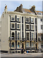
3 & 4 Pavilion Parade
Grade II listed http://list.english-heritage.org.uk/resultsingle.aspx?uid=1380711
Image: © Oast House Archive
Taken: 9 Jun 2013
0.01 miles
3
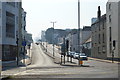
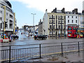
Edward Street
Viewed from the junction with Pavilion Parade. Originally the street was a narrow one that climbed the hill to the east of the Old Steine to the junction with Upper and Lower Rock Gardens. From about the 1930s onwards it began to be redeveloped initially the area on the left which became a bus depot and a pub called the Dog Tray which was later demolished to make way for the current buildings. The rest of the northern side came down during the 1960s to construct a dual carriageway which would take traffic out of the town though with a remarkable lack of foresight the planners were unable to acquire land around Brighton College and the Royal Sussex Hospital to continue the carriageway leaving its current end outside the area that was once Kemp Town station. A consequence of the widening was the construction of new buildings for the city's police and courts and from the late 1970s the European headquarters of American Express who remain one of Brighton's major employers.
Image: © Simon Carey
Taken: 19 Nov 2011
0.01 miles
5
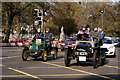
London to Brighton Veteran Car Run 2019
Grand Parade in Brighton.
Image: © Peter Trimming
Taken: 3 Nov 2019
0.02 miles
6
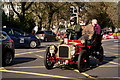
London to Brighton Veteran Car Run 2019
Grand Parade in Brighton.
Image: © Peter Trimming
Taken: 3 Nov 2019
0.02 miles
7
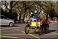
London to Brighton Veteran Car Run 2019
Grand Parade in Brighton.
Image: © Peter Trimming
Taken: 3 Nov 2019
0.02 miles
8
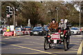
London to Brighton Veteran Car Run 2019
Grand Parade in Brighton.
Image: © Peter Trimming
Taken: 3 Nov 2019
0.02 miles
9
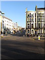
Edward Street, Brighton
Looking across Old Steine.
Image: © Robin Webster
Taken: 13 Apr 2019
0.02 miles
10
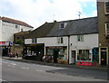
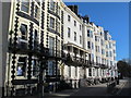
Edward Street
Head south down Grand Parade then Pavilion Parade until the junction with Edward Street is reached. Edward Street was built on what was known as a leakway a path dividing two separate Laines, in this case Hilly Laine to the north and Little Laine to the south. This area was built up from 1800 onwards and the Hilly Laine area soon became home to the town's slums. Edward Street was once only 25 feet across but the northern side was cleared and widened between 1961-64 as a planned dual carriageway out of town. The street retains a number of buildings on its southern side as a reminder of the street's previous role as a shopping area for the poorer areas of town. What shops remain now serve the big employers of the northern side of the street.
Click on the link to take you to the next page. http://www.geograph.org.uk/photo/231411
Image: © Simon Carey
Taken: 1 Sep 2006
0.02 miles