IMAGES TAKEN NEAR TO
Devonshire Place, BRIGHTON, BN2 1QJ
Introduction
This page details the photographs taken nearby to Devonshire Place, BN2 1QJ by members of the Geograph project.
The Geograph project started in 2005 with the aim of publishing, organising and preserving representative images for every square kilometre of Great Britain, Ireland and the Isle of Man.

There are currently over 7.5m images from over14,400 individuals and you can help contribute to the project by visiting https://www.geograph.org.uk
Image Map
Images are licensed for reuse under creativecommons.org/licenses/by-sa/2.0
Notes
- Clicking on the map will re-center to the selected point.
- The higher the marker number, the further away the image location is from the centre of the postcode.
Image Listing (1083 Images Found)
Images are licensed for reuse under creativecommons.org/licenses/by-sa/2.0
Image
Details
Distance

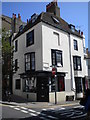
3
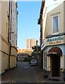
New Steine Mews, Brighton
Small cul de sac off St James's Street which was developed around the 1800s and once contained a small row of cottages and a depot.
Image: © Simon Carey
Taken: 11 Oct 2015
0.01 miles
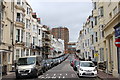
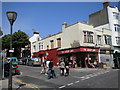
4
Devonshire Place
Head south down High Street east along St James Street then north up Devonshire Place. Constructed from 1820 onwards the street retains its original buildings and has a view of the sea.
Click on the link to take you to the next page. http://www.geograph.org.uk/photo/231672
Image: © Simon Carey
Taken: 1 Sep 2006
0.02 miles
6
Beauty Republica, St James's Street, Brighton
At the junction of Camelford Street
Image: © Robin Sones
Taken: 6 Jun 2010
0.03 miles
7
The Gossip Cafe, St James's Street, Brighton
At the junction of St James's Avenue
Image: © Robin Sones
Taken: 6 Jun 2010
0.03 miles
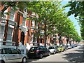
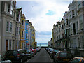
9
St James's Avenue, Brighton
A residential road that runs between St James's Street and Edward Street that was built in 1889 on the site of former slum housing containing Rock Mews and Rock Court.
Image: © Simon Carey
Taken: 11 Oct 2015
0.03 miles
10
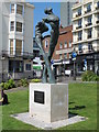
Tay
Brighton and Hove AIDS Memorial, by Romany Mark Bruce, 2009. The location of this memorial is shown in Image
Image: © Mike Quinn
Taken: 22 May 2012
0.03 miles