IMAGES TAKEN NEAR TO
Kemp Town Place, BRIGHTON, BN2 1NE
Introduction
This page details the photographs taken nearby to Kemp Town Place, BN2 1NE by members of the Geograph project.
The Geograph project started in 2005 with the aim of publishing, organising and preserving representative images for every square kilometre of Great Britain, Ireland and the Isle of Man.

There are currently over 7.5m images from over14,400 individuals and you can help contribute to the project by visiting https://www.geograph.org.uk
Image Map
Images are licensed for reuse under creativecommons.org/licenses/by-sa/2.0
Notes
- Clicking on the map will re-center to the selected point.
- The higher the marker number, the further away the image location is from the centre of the postcode.
Image Listing (300 Images Found)
Images are licensed for reuse under creativecommons.org/licenses/by-sa/2.0
Image
Details
Distance
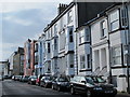
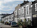
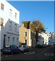
1
Kemp Town Place, Kemp Town, Brighton
These cobble fronted cottages form a private mews off Chichester Place and were built in the 1820s to serve the great and good in the newly built Lewes Crescent and Sussex Square.
Image: © Simon Carey
Taken: 4 Oct 2015
0.01 miles
2
Rock Grove, Kemp Town, Brighton
Squeezed between Image to the left and the rear of Image to the right the road was developed around the 1820s and runs from Kemp Town Place to Rock Street.
Image: © Simon Carey
Taken: 4 Oct 2015
0.01 miles
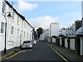
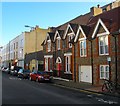
4
The School House, Chesham Road
An odd break from the prevailing tall bay-windowed B&B architecture of the area, as seen on the right. Doesn't appear to be a listed building, though.
Image: © Keith Edkins
Taken: 16 Sep 2016
0.02 miles
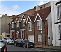
5
School House, Chesham Road, Kemp Town, Brighton
One of the many sites of St Mark's that began life in Sussex Square in 1845, moved here in 1856, then acquired larger premises in Arundel Road in the 1896, see Image, where they stayed until moving to a modern building in Manor Road in 1972 where the school still operates today as a Church of England primary. After the school moved the building was used as a church hall until St Mark's was made redundant in 1985 after which it has been converted into three properties; number 39, with the red door, now a private dwelling, as is number 39c on the right. Part of the hall to the rear is number 39b and is home to TS Nautilius, part of the Nautical Training Cadets. Beyond the entrance to the latter the road becomes Rock Street, see Image
Image: © Simon Carey
Taken: 13 Nov 2015
0.02 miles
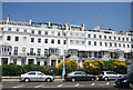
7
1, Chesham Road, Kemp Town, Brighton
Located on the corner of St Mark's Street is a former public house, the Rose & Crown, that operated here from the early 1860s until 1940. After the war it spent a few years as dining rooms but has since been converted into a private dwelling. The houses beyond St Mark's Street are in Rock Street.
Image: © Simon Carey
Taken: 13 Nov 2015
0.03 miles
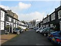
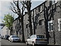
8
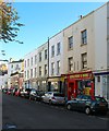
1-6, Rock Street, Kemp Town, Brighton
The street was built in the 1820s as a service street to the original Kemp Town development and as a result these buildings have generally been shops since that time. However, number 2, now Rock Food and Wine, was a public house called Horns between 1854 and 1862, as was number 3, to its left, which was the Dun Horse in 1854. Further along at number 5 is a piano specialist, whilst number 7 at the far end is Image
Image: © Simon Carey
Taken: 13 Nov 2015
0.03 miles