IMAGES TAKEN NEAR TO
Montague Place, BRIGHTON, BN2 1JE
Introduction
This page details the photographs taken nearby to Montague Place, BN2 1JE by members of the Geograph project.
The Geograph project started in 2005 with the aim of publishing, organising and preserving representative images for every square kilometre of Great Britain, Ireland and the Isle of Man.

There are currently over 7.5m images from over14,400 individuals and you can help contribute to the project by visiting https://www.geograph.org.uk
Image Map
Images are licensed for reuse under creativecommons.org/licenses/by-sa/2.0
Notes
- Clicking on the map will re-center to the selected point.
- The higher the marker number, the further away the image location is from the centre of the postcode.
Image Listing (436 Images Found)
Images are licensed for reuse under creativecommons.org/licenses/by-sa/2.0
Image
Details
Distance
1
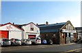
Garages, Montague Place, Kemp Town, Brighton
Two garages on the eastern side of Montague Place. Between them is Image
Image: © Simon Carey
Taken: 11 Oct 2015
0.01 miles
2
Daily Living Centre
Based in Montague House, The Centre provides free impartial information and advice, available to anyone, on all aspects of daily living equipment. There is an information service, an in-house Occupational Therapist and an equipment display comprising of products for physical, visual and hearing impairments http://www.escis.org.uk/Entry/View/Brighton_and_Hove_Daily_Living_Centre/15372
Image: © Paul Gillett
Taken: 2 Jan 2011
0.02 miles
3
The Black Horse, Brighton
Defunct pub on Montague Place.
Image: © Oast House Archive
Taken: 16 Oct 2010
0.02 miles
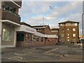
4
Telegraph Street, Kemp Town, Brighton
A small cul de sac off Monatgue Place that was originally developed in the 1810s and had a small row of cottages on its northern side that appear to have been removed in the 1930s and replaced by the current building beyond the gates.
Image: © Simon Carey
Taken: 11 Oct 2015
0.02 miles
5
Montague Place, Kemp Town
At the junction with St.George's Terrace, Bristol Road & St.George's Road near Brighton College
Image: © Geographer
Taken: 22 Mar 2018
0.02 miles
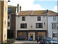
6
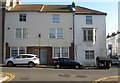
16-17, Montague Place, Kemp Town, Brighton
A former pub that operated from at least the 1850s untils its closure in 2010, see Image, since when it has been converted back into two houses, the pub originally located at 16 eventually extending into 17.
Image: © Simon Carey
Taken: 1 Nov 2015
0.02 miles
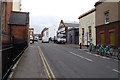
7
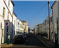
Montague Place, Kemp Town, Brighton
A residential street that runs from St George's Road to Eastern Road that was developed in the 1850s though much has now been cleared away with just the houses on the right that have survived all development schemes. See http://regencysociety-jamesgray.com/volume22/source/jg_22_211.html for the shops that once stood on the left on the corner with Somerset Street.
Image: © Simon Carey
Taken: 11 Oct 2015
0.02 miles
8
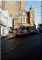
Bristol Road Methodist Church
On the corner of St George's Terrace and Montague Place it was built in 1876 and closed in 1987. It is currently being used by Brighton College, an independent school. The flats behind are Essex Place.
Image: © Simon Carey
Taken: 11 Jan 2009
0.03 miles
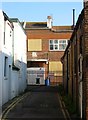
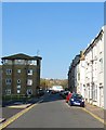
9
College Street, Kemp Town, Brighton
A residential road that runs between Montague Place and College Road that was developed from 1854 onwards.
Image: © Simon Carey
Taken: 11 Oct 2015
0.03 miles
10
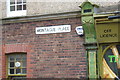
Montague Place sign
On Montague Place at the junction with St.George's Terrace, Bristol Road & St.George's Road near Brighton College
Image: © Geographer
Taken: 22 Mar 2018
0.04 miles